Obsidian Falls
Distance: 10.3 miles.
Elevation Gain: 1,850 feet.
The trail to Obsidian Falls will take you to some of the most dramatic scenery within the Central Oregon Cascades. The trail travels up through dense forest, over lava flows, and up into some high alpine meadows. And what makes the trip so memorable is the black volcanic glass from which the trail gets its namesake that glistens everywhere in the sun. Just be sure to get your limited access permit from recreation.gov prior to going, as this is a limited entry area and the fines for being caught without a permit can be steep.
The trail begins from the Obsidian Trailhead just west of the summit of McKenzie Pass. The trail departs from the eastern end of the parking area and immediately dives into a deep forest of Lodgepole Pine, Douglas Fir, and hemlock. You will enter the Three Sisters Wilderness in a little less than a mile and shortly after you will encounter a side trail to your right that could take you to Spring Lake in about ½ a mile. While not that far away, this is a fairly long hike so you can make the judgement on if it is worth the extra mile.
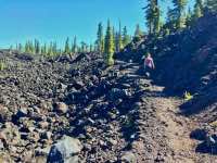
The trail remains in the forest for just under 3 miles before you find yourself climbing up onto a river of lava. This lava was expelled from Collier Cone some 1,500 years ago and raced down the White Branch of the McKenzie River for a full 7 miles before finally stalling out. This is also where the views really start to open up. Both North and Middle Sister will loom ahead of you and the Obsidian Cliffs can be seen across the flow.
Once you cross the flow, you will drop down into a nice little meadow with a stream running through it, depending on the time of year. After crossing the stream the trail will soon split, with the Obsidian Falls trail continuing toward the right and the Glacier Way trail on the left. Head to the right and climb back into the forest. The trail will continue like this for another couple of miles, alternating between forest cover and small meadows with the occasional view of the mountains popping up.
Finally, at a little over 5 miles, you will reach the junction with the Pacific Crest Trail. Turn left and head north on the trail and you will come to Obsidian Falls very quickly. The falls itself is not overly impressive with a drop of probably 30-40 feet, but if you take notice of some of your surroundings, how truly special this place is becomes apparent. First, the falls is cascading over a cliff of obsidian. Also, look around. That boulder you’re sitting on. Yup its obsidian as well. Don’t cut your butt.
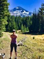
Once you’ve finished your lunch, hop up and continue north along the PCT. This mile stretch of the PCT is truly spectacular as the trees drop away and the views open up before you. Little shards of obsidian glisten everywhere. Take in Collier Glacier, the largest glacier in Oregon, spilling off of North and Middle Sisters. Little pocket lakes also dot the landscape.
After a very satisfying mile along the PCT, you will come again to the Glacier Way trail, splitting off to your left. This will lead you along a steep decent back to the Obsidian Falls trail near the lava flow. Once you reconnect back with the trail, head back over the lava and enjoy the final 3.5 miles back to your vehicle and the adult beverage I’m sure you don’t have waiting for you.
Directions
From Sisters, head west on Highway 242 over McKenzie Pass. The trailhead will be on the west side of the pass, 21 miles from Sisters, on your left. From Eugene, head east on Highway 126 until you reach the junction with highway 242 after 56 miles. Head right onto 242 and continue up the pass for 15.5 miles. Make note that McKenzie Pass is closed for the majority of the year. It closes once the snow starts to fall and usually doesn’t open again until sometime in June or even July.
Things to Know
Passes: A Central Cascades Wilderness Permit is required to access this area between June 15th and October 15th. The permits will be available from recreation.gov and will go on sale in early April. A Northwest Forest Pass is also required to park at this trailhead.
Dogs: Allowed and must be on leash or under voice command at all times.
Usage: Moderate
Open Season: Higher elevation trails usually melt off sometime in July and remain open until the first snow falls.
Bugs: Mosquitos can be bad during the melt season, usually June-July, then will mostly clear up moving into August.
Flowers: Different flowers will bloom depending on elevation, but July and early August are usually peak months.