Multnomah - Wahkeena Falls Loop
Length: 4.9 miles
Elevation Gain: 1,600 feet
Multnomah Falls is an icon of the Pacific Northwest, drawing in more visitors than any other natural recreation site in the region. The two-tiered, 635 foot drop, is the tallest perennial waterfall in Oregon and the scene, the green grotto and beautiful Benson Bridge spanning the lower tier, make for something straight out of a storybook. Just be prepared to share it with the more than 2 million annual visitors who stop by each year to take in the views.
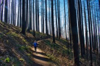
The Multnomah – Wahkeena Falls Loop includes many more waterfalls than just this stately treasure. Five other named waterfalls, plus countless other cascades can be found along this magical loop. Tragically, much of the area was burned during the 2017 Eagle Creek Fire, but even despite the blackened trees, this is a hike you will never forget.
The hike can be started from either the Wahkeena Falls Trailhead or at Multnomah Falls, and can go in either direction. This description starts at Multnomah Falls, because there is way more parking there, and heads clockwise around the loop.
Begin your hike at the viewing area of Multnomah Falls, near the lodge. This lodge offers a variety of things, such as gifts, snacks, restrooms, and even a restaurant, if you feel like sitting your sweaty, post-hike butt down and grabbing a tasty dinner or lunch. The pool below the lower falls and the viewing area used to be a swimming hole, with kids collecting coins from all over the world at the base of the falls. All this ended in 1995 when a 400 ton boulder the size of a school bus broke free from the cliff and came crashing down to the pool below, resulting in a splash that was 70 feet high.
The trail up to the top of Multnomah Falls is paved for the majority of the climb. It begins climbing immediately as it switchbacks up behind the lodge. Soon, in less than a quarter mile, you will come to Benson Bridge. Cross over the bridge as it passes above the lower falls, right at the base of the upper one. Then pull up your big girl panties cause you got some climbing to do.
The next ¾ of a mile will march you up through 11 numbered switchbacks as you climb almost 650 feet to the top of the falls. The views of both the falls and the Columbia River are breathtaking as you make this climb, but the drop-off off the side of the trail is extremely steep. Soon (it won’t feel like soon), you will reach the junction with the Larch Mountain Trail and the Multnomah Falls viewpoint. Its only .15 miles to the viewpoint (although you do have to descend about 100 feet, which means you have to climb back up again. More climbing!!) but the opportunity to stand over the lip of the tallest falls in Oregon is not something one should forgo.
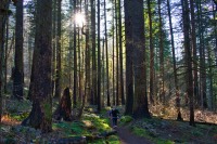
After the trip to the viewpoint, head back to the trail junction and continue up the Larch Mountain Trail. There is a pretty unnamed waterfall right near this junction as you pass over a culvert over Multnomah Creek. The trail continues to climb up the creek, gaining another 500 feet in about half a mile. You will pass three more waterfalls along this stretch, Dutchman Falls, a 15 foot tall, 20 foot wide drop, Wiesendanger Falls, a 55-foot cascade into a beautiful pool, and finally Ecola Falls, another 55-foot drop that is partially hidden from the trail. You will also pass through a creek washed overhang called Dutchman Tunnel, from which Dutchman Falls was named.
A quarter mile past Ecola Falls, you will come to the trial junction with the Wahkeena Trail. Make a right and continue climbing as the trail rounds the nose of the ridge above Multnomah Falls. You still have 350 feet to climb in the next ¾ of a mile as you work your way through the blackened remains of the forest. You will reach the highpoint of the climb near where you cross over little Shady Creek. The trail then begins descending towards two different rail junctions in rapid succession. Remain on the Wahkeena Trail at both intersections, passing by both the Devil’s Rest Trail on your left and the Vista Point Trail on your right.
Following the Vista Point Trail Junction, things really being to go downhill (I made a pun!). You will reach the intersection with the Angel’s Rest Trail in about 1/3 of a mile. If you want, you can head a short distance down the Angels’ Rest Trail to view Wahkeena Spring, which gushes from the ground as a full blown creek in a nice patch of Cedars. Head back to the previous intersection and continue down the Wahkeena Trail.
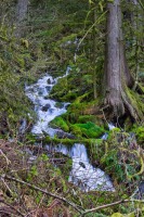
The Wahkeena Trail seems to switchback pretty much all the way back to the Columbia River from this point. After, oh, let’s say 8 or so, you will come to beautiful Fairy Falls. You will pass over some boards right at the base of the fanning waterfall as it cascades 20 feet down a rocky face right in front on you.
A few more switchbacks remain as you continue to hike down Wahkeena Creek. You will then cross over a bridge and enter a very narrow section of the canyon. The narrow canyon is short lived, however, and once you emerge, head straight down the ridge and make the short side trip to Lemmons Viewpoint. The views of the Columbia extend from Cape Horn to Beacon Rock.
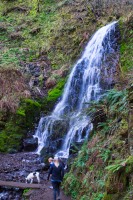
Head back to the trail as it transitions to a paved path once again and begins another series of 500 switchbacks (It might be 11, but 500 sounds better). After the final switchback, the trail heads to the west and crosses a stone bridge near the base of Wahkeena Falls. The falls drop 242 feet in two tiers. If the flow is up, expect to get sprayed as you pass over the bridge. Following the bridge, the trail continues to the west, before turning back to the east as you approach the highway. You will cross over Wahkeena Creek once more, and get to view the falls from the highway viewpoint here. While you can see more of the falls from here, much of it can oftentimes be obscured by trees and leaves.
Following Wahkeena Falls, hop on the return trail and begin to make your way back to Multnomah Falls. This undulates up and down as it parallels the highway for the final 0.6 miles to the lodge. There are some cool rock faces where springs emerge, and you pass under a basalt overhang just to make this final stretch interesting.
Directions
On I-84, take exit 31 towards Multnomah Falls. This parking area is located between both east and west bound lanes and can be accessed from either direction. However, because of the popularity of the site, the parking lot is oftentimes full, and when it is, automatic gates will close on the freeway exits. If the lot is full, you can try parking at either Multnomah Falls or the Wahkeena Falls Trailhead on the Historic Columbia River Gorge Highway, but both these parking areas are very small and also likely to be full.
One final option is that you can continue past exit 31 if the gates are closed and to head to either exit 44/Cascade Locks in you are headed Eastbound or exit 25/Rooster Rock if you are headed westbound. At Cascade Locks, you can park in town somewhere and board the Columbia Gorge Express at WaNaPa Street. The shuttle will take you to Multnomah Falls and back for $1 per trip. From Rooster Rock, you can pay $5 to enter the park and then ride the free shuttle to Multnomah Falls.
Things to Know
Passes: Between late May and Septmeber, permits will be required for all vehicles accessing this area. One permit will allow access tot he Multnomah Falls parking area off of I-84 and a second permit allows vehicle access to the Historic Columbia River highway between the Bridal Veil and Ainswroth Exits. Permits can be purchased on recreation.gov up to two weeks in advance and are $2 each. Another option is to take a shuttle bus into the area, as permits are only required for vehicles.
Dogs: Allowed and must be on leash.
Usage: Heavy
Open Season: All year. Winter storms may result in ice and make the trip very unpleasent.