Painted Hills - Painted Cove
Distance: 0.4 miles.
Elevation Gain: 70 feet.
The Painted Cove Trail is located within the Painted Hills Unit of the John Day Fossil Beds National Monument. The Painted Hills are made up of different bands of clay where were deposited around 35 million years ago. The different colors of the bands indicate the climate that was present in the region during their deposition. The red and yellows within the hills are soils rich in iron and aluminum, with the reds indicating tropical periods and the yellows times that were cool and dry. The black streaks and spots within the hills were likely the remains of plants and are high in manganese. The colors of the hills are usually the most dramatic following some rain, or early or late in the day. If you visit during the height of the day in the summer and it hasn't rained in two months, they may appear a little washed out.
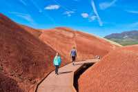
The hike along the Painted Cove Loop begins from its appropriately named trailhead, near the Painted Hills Reservoir. Unfortunately, the reservoir is private property, so no swimming on a sweltering eastern Oregon summer day allowed. If you want to get wet, you have to go play with the beavers, rattlesnakes, and ticks along Bridge Creek. The trail immediately splits from the trailhead, with the left course heading up a nice, wooden walkway through a gap in the hills and the right heading around the hill. I prefer to head to the right and save the scenic jaunt down the walkway for last, but I will leave the decision up to you.
You have the opportunity to go a little rogue on this hike. Just above the wooden walkway, there is a side trail that travels about 300 feet, climbing an additional forty feet to a little point above the cove. This vantage point gives you a nice view out over the hill and on to the reservoir behind it. I recommend taking this short detour if you feel you’re up to the challenge.
Directions
To reach the Painted Hills, travel east on Highway 26 for 43 miles until you reach the sign for the Painted Hills Unit of the John Day Fossil Beds National Monument, about 4 miles west of Mitchell. Head north on Burnt Ranch Road for 6 miles. Right before the pavement ends, take a left and make your way into the park. Once you cross the bridge over Bridge Creek, you can head to the left if you need to use the bathroom to go straight ahead to view the hills. Drive along the main road up and over the saddle and the trailheads for the Overlook and Carol Rim Trails. Continue 0.7 miles down the backside of the hill and take a right on the road where you will see a sign directing you to the Painted Cove. The trailhead is a short 0.4 miles down this road.
Things to Know
Passes: No passes are required.
Dogs: Allowed and must be on 6' or shorter leash.
Usage: Moderate
Open Season: Open all year. Can get very hot in the summer.
Flowers: Wildflowers will typically bloom in April-May.