Peterson Ridge East
Distance: 3.0 mile
Elevation Gain: 260 feet.
The Peterson Ridge Trail network is primarily a series of mountain bike trails just south of Sisters, with a few horse trails thrown in for some good measure. However, if you are looking for an off-season hike, you can find yourself a nice trail and likely only experience a few other hikers.
The east end of Peterson Ridge can be accessed through a variety of different points. The most obvious of those is the Peterson Ridge trailhead located just south of Sisters. However, these being designed as mountain bike trails, you would find yourself strolling through at 8 miles of featureless, flat, ponderosa pine forest that you don’t’ need to. Your best bet is to head down Forest Road 4606, which, while a good rad with a nice, packed and rocked surface, seems way rougher than it needs to be. Once you reach the intersection with Peterson Ridge Road to the left and Forest Road 100, to your right, look for a nice pull out along the left side of 4606 and being your hike here.
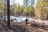
Start my walking just a short distance down the 100 road, heading west. This is just the simple two track road, not the other three wide, gravel roads. Soon, you will encounter a sign pointing you to a horse trail to Peterson Ridge Overlook. Make a left and continue up this old two-track road.
There are a ton of different trails, both mountain bike and horse, that you can explore in this area. The route combinations are plentiful. From this point on, this trail description just marks the most direct route up to Peterson Ridge Overlook. You will cross over a mountain bike trail while on the horse trail after about half a mile. Stay on the horse trail and continue on for another tenth of a mile. Here you will run across a trail junction with kind of confusing sign. It points that Peterson Ridge Overlook is straight ahead, but there is no trail straight ahead. So just veer to the right and continue along the horse trail.
The horse trail remains a two-track road for another third of a mile before you hit another junction with a mountain bike trail. Make a left here and follow the mountain bike trail over an old ditch and begin the climb up Peterson Ridge. It’s not too steep of a climb and it’s kind of nice trading the two-track road for a single-track trail. Just keep your eyes peeled for bikers if you are here during prime biking months.
The trail performs one sweeping switchback as it climbs the ridge and the proceeds along the its edge. You will start getting some peak-a-boo views of the mountains through the trees, primarily Three Fingered Jack and Black Butte. The trail hugs the ridgeline for about a half of a mile before reaching the overlook. There is a picnic table and hitching pose here, if you want to sit, grab some lunch, or tie someone up. There is a rock outcrop jutting away from the ridge and this is where you will find the best views. It requires a little scrambling and doesn’t really have a great place to stand or sit, but the views, especially of the Three Sisters, are awesome.
Directions
The most direct route to the trailhead is to head south of Sisters on Elm Street towards Three Creeks Lake. A mile after crossing the bridge over Whychus Creek, make a left onto Forest Service Road 4606. This is a nice, wide road and if they ever perform maintenance on it again, would be a very easy path towards the trailhead. Now, the road is full of potholes, bumps, and other issues that make it harder to drive more than about 10 mph on it. Regardless, follow the road for 2.4 miles until you reach a 4-way intersection with Peterson Ridge Road and Forest Road 100. There will a sign on a tree saying the road straight ahead is closed during winter months, with a map attached to it. Flip around and park on a nice, wide shoulder, just north of Peterson Ridge Road.
If you don’t feel like driving 2.4 miles over a crappy, bumpy road, you can take Highway 20 three miles east of Sisters and make a left onto Harrington Loop Road. Follow Harrington Loop Road for 0.6 miles and make a right onto Peterson Ridge Road at the first 4-way intersection. Follow Peterson Ridge Road for 0.9 miles until you reach the intersection with the 4606 road. Now you only had to drive 1.5 miles over crappy, bumpy roads.
Things to Know
Passes: No passes are requried.
Dogs: Allowed and must be on least or under voice command at all times.
Usage: Moderate
Open Season: Open and accessible all year. The trail can get hot and dusty in the summer and may be covered in snow or will be muddy or icy at times in the winter. You will also encounter more mixed users, like mountain bikers and horses, from around Apil til November.