Columbia Hills -Stacker Butte
Distance: 4.8 miles.
Elevation Gain: 1,150 feet.
The Columbia Hills Nature Preserve lies along the crest of the Columbia Hills near The Dalles, the peak of which is Stacker Butte. The preserve was established in 1993 to protect the largest populations in Washington of three endangered plant species, obscure buttercup, Douglas’ draba, and hot-rock penstemon. There is also a lot of arrowleaf balsamroot. I mean, a lot. It carpets the entire mountainside in the spring. For 10 months out of the year, this area may be drab and brown, but in April and May, it can be a wildflower wonderland.
Begin your hike from the end of the road that spurs off The Dalles Mountain Road and heads straight up Stacker Butte. There will be a parking area, along with some informational kiosks and the road will be gated at that point. This hike doesn’t follow an actual trail, but the road to the summit, but the views and the flowers make it worth it.
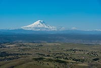
The hike is a pretty steady climb towards the summit of Stacker Butte, and surprisingly steep considering you are following a road. As you climb, you will be granted with some amazing views of the hills folding away beneath you, and Mt Hood towering over the Columbia River and The Dalles Dam. Depending on the year and the time of the year you are visiting, the balsamroot, along with Lupine and Paintbrush, will be blooming in bands across the hillside, moving up the hill as the year goes on.
As you begin winding your way through the switchbacks along the road, you will start to see a radio tower on what looks like the top of the hill. You will start thinking that doesn’t look too far away. This is a piece of cake. Then you will get there and realize that you are wrong. You will see another radio tower (it kind of looks like an alien spaceship surround my laser turrets, but maybe that’s just me) in the distance. You will still have almost a mile and 400 vertical feet to go. You will probably be above the flowers at this point and you may be thinking, screw it, I’ve seen enough. You should continue.
After you push through that last mile, you will finally crest onto the summit of Stacker Butte. There will be with weird radio building in front of you and Mt Hood’s snowy flanks glisten in the sunlight (I’m like a poet). Continue around the radio building towards the north, and soon, you will see Mt Adams rising in front of you. Head to the northern edge of the butte for some amazing views, where Mt Jefferson, Hood, St. Helens, Adams, and Rainier can all be seen. Told you it was worth it.
Directions
From The Dalles, take US-197 over the Columbia and then an additional 2.5 miles until you reach Highway 14. Turn right on WA-14 and look for Dalles Mountain Road in 0.9 miles on your left. Head up the gravel road for 3.4 miles until you reach the Dalles Mountain Ranch section of Columbia Hills State Park. When you see an old wagon and barn, you will see a road that heads to the right and climbs straight up the hill. Turn onto the road and the trailhead will be 1.4 miles further up. There may be hikers hiking along the road, so take it slow.
Things to Know
Passes: A Discovery Pass is required at the trailhead.
Dogs: Dogs are not allowed in the nature preserve
Usage: Moderate in the spring, mainly weekends, but pretty light the rest of the year.
Open Season: All year but the flowers will be in their peak in April and into May.


