Tam-a-láu Trail
Distance: 6.5 miles.
Elevation Gain: 640 feet.
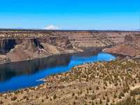
The Tam-a-láu trail is a beautiful loop that takes you by a point on a plateau near where the Crooked and Deschutes Rivers meet in Lake Billy Chinook. Tam-a-láu is a Native American term meaning “place of big rocks and ground” and the name certainly fits. The views from the steep cliffs looking out over the two arms of the reservoir at the same time are truly spectacular.
The trailhead is located at the Upper Deschutes Day Use Area, on the right side of the road as you drive through the park and past the boat ramp. The trail leaves the parking area from the southeast corner of the lot and parallels the road through the juniper for about half a mile before it crosses both the day-use area road and then the main park road. After crossing the main road, head through a gap in the fence and continue on towards the Deschutes Campground for about 300 feet where signs will direct you to the trail on your right.
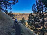
Once past the campground, the Tam-a-láu trail begins climbing steeply. The trail climbs over 500 feet in the next mile until you reach the top of the plateau. Enjoy multiple viewpoints overlooking the Deschutes Arm and marvel in the basalt columns within the cliffs as you pass under them. As you near the top, you will punch through a break in the cliffs and make one last 100 foot push as you scramble up to the top of the plateau.
From here, the Tam-a-láu trail begins its 3.5-mile loop on the plateau. Take the trail to the left and head along the rim overlooking the Deschutes. The mountains stretch out before you and, if you come during wildflower season, blooming phlox, death-camas, balsamroot, yellow bells, and yellow-stars will dot the landscape. The trail will hug the cliff-face for a little over a mile until you reach the terminus of the plateau, overlooking both the Deschutes and Crooked arms of the lake.
Enjoy the vistas and continue along the loop heading up the Crooked Arm. The cliffs are even more dramatic along this stretch and the bridge over the Crooked looks like a child’s toy below you. Again, it’s a little over a mile before the trail turns inland and heads back towards the Deschutes. Things can get a little confusing on this stretch with old jeep and powerline roads crossing the trail haphazardly. Just try and stay on a path that resembles a trail and keep heading in a predominately westward direction and you will end up where you’re supposed to. Once you reach the end of the trail, just re-trace your route back down the plateau and to your waiting vehicle and houseboat I’m sure you have rented and moored for you on the lake.
Directions
From Highway 97, make your way towards Culver between Redmond and Madras. From Culver there are numerous signs directing you to the Cove Palisades State Park. From the south end of town, take Iris Lane west for 1 mile until reach Feather Dr. Make a right onto Feather Drive and drive for 1.2 miles. Then, make a left on Fisch Lane and continue for half a mile before making another right on Frazier Drive. A half mile down Frazier drive, make a left onto Jordon Road right in front of the Cove Corner Store. Follow SW Jordan Road for 5.5 miles as it winds its way down the canyon, and over the Crooked Arm. The Upper Deschutes Day Use Area will be on your right after you make your way around to the Deschutes. If you cross the bridge over the Deschutes, then you’ve gone to far.
Things to Know
Passes: A $5 day use permit is required.
Dogs: Must be leashed.
Usage: Light
Open Season: Open year round. Can get very hot in the summer.
Flowers: March through April.