High Rim Loop
Length: 4.6 miles
Elevation Gain: 600 feet.
The Slide Mountain area off of the Walton Sno-Park offers some of the best snowshoeing trails in the Ochocos, and the High Rim Loop grants some of the best views without having to commit to hours and miles of uphill travel. The rim near the base of Slide Mountain on which the High Rim trail traverses offers unobstructed views to both the north and south, and the wide open stands peppering large, open snowfields make this one of the most memorable trips in the Ochoco National Forest. Plus, the trail was relatively easy to follow, a definite plus in the Ochocos.
Begin your snowshoe from the Walton Sno-Park at the end of Forest Road 22 (The winter end anyway). There is a nice warming shelter on the upper terrace of the parking lot if you would like to sit back and relax following your excursion. Leave the parking area down the hill past the snow shelter and restroom, heading towards the entrance of the Sno-Park. Cross the entrance road and you should notice a groomed trail heading across the unplowed road and towards the north.
You will quickly encounter trail junction A, and another groomed trail will head off to your right. Follow this trail for about 500 feet, but keep an eye out for some blue diamonds on your right. You will soon see the trail break away from the groomed path and head through an open patch towards some timber. This is the Ochocos, so there may not be any other tracks to follow, but most of this trail is adequately marked.
The trail seems to follow an old road the majority of way towards junction J. It follows some natural breaks in the trees and slowly climbs 200 feet in just over 1.5 miles. There are a few places where things can get confusing, as you head across a large open area and can’t find any marked trees. Just head across and look for the blue diamonds on the far side, you can usually find them. Sometimes, also check the backside of small trees growing in the openings. There are quite a few diamonds on only one side of some tiny little trees.
You will know when you hit junction J when you find an empty sign board planted near the edge of the rim. From here, the trails head to the right to climb Slide Mountain, head straight over the rim for the Drop-Off trail, or head to the left up the edge of the rim for the High Rim Trail. Head left, cause that’s the way we went and I can’t properly guide you otherwise.
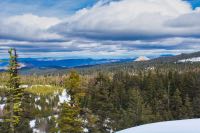
Once on the High Rim trail, you will begin climbing more steeply, gaining over 100 feet in a little more than a quarter mile. As you head up, the earth will fall away from your right, so don’t get too close to the edge. The trail doesn’t quite climb to the very peak of this hill and will angel towards the left just before the top. At this point, be sure to head for an opening in the trees and check out the view to the north. The arid John Day country spreads out before you with endless rolling hills. Black Butte and White Butte dominate the landscape, and it is pretty cool to be able to look down on them. Further to the north, the Painted Hills are tucked away.
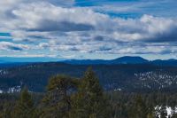
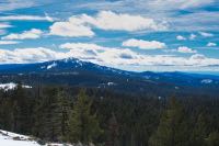
Head back to the trail and continue on your way. The trail skirts around the small high point and then works its way back to the edge of the ridge. The trees are thicker here, and there isn’t much of a view. About a half mile from the viewpoint, the trail will swing towards the south and begin slowly climbing again. A quarter mile more will find you snowshoeing along a wide open meadow, with the snowy horizon just seeming to disappear to your right. Make sure to head off the trail and march up to the top of this ridgeline. The views extend from the Cascades to the west and Round Mountain to the south. It’s a beautiful spot to take a break and enjoy the scenery.
Once you are ready, head back towards the tree line and find the trail once more. The trail will drop pretty quickly off the eastern side of the ridge and then loop around the south end. The side-hilling through this stretch can kind of suck, but it isn’t for too long and at least you are going downhill. In a little less than a mile, you will reach junction H. Make a left and begin your final leg home.
You have a little more than a mile along this final trail back to the Sno-Park. This area is more heavily wooded and not quite so pretty, but it is relatively flat. You will pass Junctions B, C (supposedly. I have never found Junction C. I think it is a sham), and A before reaching the Sno-Park. Stay to the left at B and C (if you can find it) and by the time you reach A, you should be able to see your destination. Those who designed the trails throught it would be funny to have a final half mile of uphill at the end, just because they figured you weren’t tired enough yet. Jerks.
Directions
To reach Walton SnoPark, head east from Prineville on Highway 26. After 15 miles, head right onto Ochoco Creek Road where the signs direct you to Walton Lake. Continue on Ochoco Creek Road for 8.5 miles until you reach the intersection with NF-22. Make a left here. A sign will also be present directing you towards Walton Lake. The SnoPark will be 7.5 miles up this road on your right.
Just as a precaution, the road up to the SnoPark is only plowed once per week. If it has snowed a bunch and you are trying to get up there on the wrong day, you may not be able to make it.
Things to Know
Passes: An Oregon Sno-Park permit is required November 1 through April 30.
Dogs: Allowed and must be on leash or under voice command at all times.
Usage: Light
Open Season: As long as there's snow. The Ochocos don't get near the snowpark the Cascades do, but there should be 1-3 feet between Christmas and March, most years.
Hazards: Although this trial is better marked than many other Ochoco trails, it still isn't heavily traveled, so be sure to bring a map and GPS so you know where to go.