Vista Butte
Length: 5.2 miles
Elevation Gain: 700 feet.
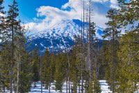
Vista Butte is a beautiful little hill located right off the highway on the way up to Mt Bachelor. Its 6,600 foot summit is just free enough of trees to offer some stunning views of Mt. Bachelor, Tumalo Mountain, South Sister, and Broken Top. On a clear day, you can see all the way to Mt. Thielsen. So strap on your snowshoes and make this short, but extremely satisfying climb.
Your journey will begin from the Vista Butte Sno-Park, a simple wide spot on the road right before the Cascade Lake Highway splits at the Sunriver turnoff. There isn’t much room for parking here, so if it happens to be full, you can always head to Kapka Butte Sno-Park. This would add about a mile, round trip, to your trek, but at least you won’t have to re-plan your day.
From the parking area, head up to the information kiosk. Here you will see trail markers and likely some tracks heading to the west. The trail will parallel the highway for a little more than half a mile until it begins to turn northward. Soon after that, it will switch back towards the east as you climb a small ridge. It will be amazing how quickly the traffic noise disappears.
Soon after turning eastward, you will reach a trail intersection with the Lower Loop. Stay to the left on the Butte Trail (I will explain why later. Be patient, damnit) and continue marching through the woods. You will cross a snowmobile trail in 0.4 miles, but the trail is easy to pick up again on the far side. The 0.6 miles of the Butte Trail are fairly flat, climbing only 100 feet until you reach the upper intersection with the Lower Loop trail. Head straight here and begin your climb up the butte.
The trail will weave its way through the trees as it makes its way up some small bowls on the lower slopes of Vista Butte. After another 0.7 miles and a couple hundred feet of climbing, you will reach another intersection, this time with a trail that will take you to Swampy Sno-Park at a place called Bruce’s Ballpark (no idea on that one). Don’t go that way. It will make your day way longer. Head to the right up the Vista Butte Trail. You are only half a mile from the summit. Still almost 300 vertical feet to go, but only half a mile!
This section can get a little tricky as you climb up the western face of the butte. The ground is on the steeper side, and you will be side-hilling across the face as you climb. This can get a little tiresome if there isn’t a beaten down path already in place. But that only lasts for about a quarter of a mile and you will reach the southern tip of the summit ridge. Make a hard left and follow the ridgeline to the summit.
Have fun admiring the surrounding peaks from the top of Vista Butte. Maybe grab a snack. Do whatever you want. You earned it. Then start heading back. There are some different options open to you on the way back, if you are of the adventurous mind (and are skilled at route finding. If you can’t find your way out of a paper bag, stay on the damn trail). Because of the openness of the forest on Vista Butte, and because the trail did a lot of winding around on its way up, you can skip a lot of those turns and just head straight down. If you head down the western face, and stay above the steeper drop to the south, you can have a very pleasant journey bounding through untouched snow. It will also kick you back out a little above the intersection with the Lower Loop Trail. It will shorten your trip and it is a lot of fun.
Once you reach the intersection with the Lower Loop trial, this time, take it. The trail will head southeast and climb just a tiny bit before swinging back to the southwest. Here, you will sidehill along a ridgeline for just about 500 feet or so until you have to cross the snowmobile trail again. Find the trail on the other side and keep trekking.
Once across, you have another decision to make. You can continue following the trail for another 0.4 miles until you reach the first intersection you came to, or you can bushwhack it again. If you continue on the trail, the path will remain fairly level as it meanders through the trees. Once you reach the intersection, continue west and head around the bottom end of the ridge as you march the final 0.6 miles back to your car.
Or… Or, right after you cross the snowmobile trail, look for a small saddle to your left between two small hills. Head through the saddle (It will be easy cause you won’t want to go uphill (Just make sure you are heading more southerly, not following the snowmobile route to the east)), and soon you will find yourself on top of a small ridge, right above the sno-park. Head down a small draw in the ridge (It is on the steep side, but not very far) and you will be back after only a third of a mile, as opposed to over a mile if you follow the trail. Either way, it makes for a great trip!
Directions
Follow the Cascade Lakes Highway 16 miles west of Bend. The Vista Butte Sno-Park will be located on the right side of the highway right before the highway splits at the Sunriver turnoff. It is merely a wide spot in the road, but there are signs letting you know that you are, in fact, at Vista Butte Sno-Park. If the sno-park is full, continue on and head south on Highway 45 towards Sunriver. The Kapka Butte Sno-Park will be on your left almost immediately.
Things to Know
Passes: An Oregon Sno-Park permit is required November 1 through April 30.
Dogs: Dogs are not allowed in this area.
Usage: Moderate
Open Season: As long as there's snow. This Sno-Park is at almost 6,000 feet, so it usualy has fairly consistent snowpack.