Canyon Creek Meadows
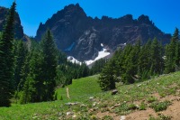
Canyon Creek Meadows, located right at the bottom of Three Fingered Jack, is one of those magical places that really epitomize what hiking is all about. The scenery is breathtaking, the mountains are rugged, the meadows are flower filled. There are lakes, streams, waterfalls, a glacier, huckleberries to snack on……. What more could you ask for. Maybe less early summer mosquitoes, but damn, you are one picky bastard.
The trial to Canyon Creek Meadows begins at the Jack Lake Trailhead. The trail begins by heading north out of the parking lot, directly towards Jack Lake. It skirts the east shore of the lake before beginning to climb a ridge and angling towards the west. The first mile of the mile travels through the remains of the 2003 B&B Fire which decimated much of the forest between Santiam Pass and Mt Jefferson. The area is recovering, however, and the lack of trees do afford some better views. But it can also be hot and dusty until your reach the shade, so make sure you have plenty of water.
Just past the lake, a little less than half a mile from the trailhead, you will encounter a trail junction, with the left heading towards Canyon Creek Meadow and the right towards Wasco Lake. The right will also get you to Canyon Creek Meadows, but the forest service recommends hiking the loop to limit encounters with other hikes. So, head to the left and keep climbing for another mile you lucky duck you.
You will crest the ridge right as you begin to enter a thicker forest. Head downhill for another half mile until you reach another trail junction at the lower Meadows. Here, Three Fingered Jack looms above the trees and a sign directs you to continue around the loop. You will notice another trail heading towards the mountain, deeper into the meadows. Your soul aches to take that trail, doesn’t it? Yeah, you should take that trail.
Head to the left and cross a small bridge over a creek. The trail seems to take dead aim at the mountain as it works its way in and out of grassy, flower-filled meadows. Unlike many of the larger peaks in the Three Sisters Area, Three Fingered Jack is a shield volcano rather than a stratovolcano, more similar to Paulina Peak. However, due to heavily glaciation, the mountain is deeply eroded, leaving a narrow dike supporting plugs from many different vents as a summit.
The trail between the lower and upper meadows is only about three quarters of a mile with about a 400 foot climb. The views are so spectacular, you will barely notice you are marching uphill. After reaching the lower Meadow, all the trails you are following are user trails, so they kind of go everywhere. But just keep aiming towards the mountain and you will pop out about halfway up a giant moriane, just above the upper meadows in no time.
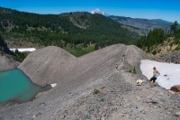
Upon reaching the moraine, you can continue on another 0.15 miles up to a moraine sitting above a pretty little glacier lake. This section definitely gets steeper, climbing another 150 feet, but the views are incredible. There will be some scrambling involved, as the trail kind of disappears into a boulder field, adn the ground gets very loose. Once up there, if you are up to the challenge and enjoyed the scrambling, you can follow a user trail towards the ridgetop on the east arm of the mountain. This requires about another half mile and 400 feet of climbing, but offers views from Jefferson to the Three Sisters.
If you climb up to the saddle, be sure to follow the ridgeline to the left, away form the mountain. This will take you to a whole other arm of the mountain, with some easy trails meandering all over. As you stroll around, you will notice an amazing overlook, sitting on the edge of a cliff above the moraine lake and straight across from the east face of Three Fingered Jack. The view is breathtaking. And keep your eye out for mountain goats up there. They like to stroll around on the steep, loose rock.
Be careful on the way down, because the saddle and morraine are very loose and steep. On the way back, rather than follow the trail back into the trees halfway down the moraine, continue following it towards teh bottom and enter the upper meadows. There can be so much lupine here, the meadows look like a purple haze, all the way from up on Three Fingered Jack. Follow the trails as they hug Canyon Creek through the meadows until it loops back around with the path you followed on the way in
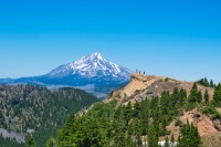
Once you reach the lower meadows again, be sure to follow the loop and take the left trail out of the meadows. This trail, while a half mile longer than the trail in, is probably the nicer of the two paths. It will follow Canyon Creek for a while, and remain in the nice shade of the trees for longer. You will encounted a junction with the Skyline trail about a mile before the trailhead. The left path heads over the creek and towards Wasco Lake. Head to the right and keep your eyes open for a pretty little waterfall just past the junction. The trail once again travels through the B&B scar, but does offer some pretty views of Jefferson as you head back to the start.
Directions
To reach Jack Lake trailhead, take Highway 20 north from Sisters for about 12 miles. Turn right onto Forest Road 12, just before the highway makes a sharp turn to the left and heads past Suttle Lake. Stay on 12, which remains paved, for about 4 miles, until you see a sign for Jack Creek. Head to the left, on Road 1230, which will quickly head over a bridge and then turns to gravel. The paved section of the road is almost worse than the gravel, with giant potholes everyhwere, so keep your eyes open and drive slow. After crossing over Jack Creek, the road turns to gravel and is 7 steep, washboardy miles until you reach the trailhead, but most vehicles should be able to make it if you take it easy.
Things to Know
Passes: A Central Cascades Wilderness Permit is required to access this area between June 15th and October 15th. The permits will be available from recreation.gov and will go on sale in early April. A Northwest Forest Pass is also required to park at this trailhead.
Dogs: Allowed and must be on leash or under voice command at all times.
Usage: Heavy
Open Season: The trail will be mostly snowfree in June and will reamin so through Novemeber, most years.
Bugs: Mosquitos can be bad during the melt season, usually through early August, then will mostly clear up moving forward.


