Chush Falls
Distance: 5.7 miles.
Elevation Gain: 660 feet.
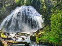
Chush Falls is a beautiful, fanning waterfall along Whychus Creek above Sisters. This area of Whychus Creek and its tributaries probably contain the greatest concentration of large waterfalls within Central Oregon as the Cascades' meltwater come crashing down the volcanic plateau of the Three Sisters Wilderness. Three of those falls are observable on this trail.
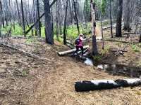
The trail to Chush Falls begins at the Chush Falls trailhead, located about 4.5 miles west of the Three Creeks Lake Road south of Sisters. The trail heads out of the south end of the parking lot along an old road that was closed following the Pole Creek Fire in 2012. The trail follows the old road for about a mile, before reaching the old trailhead. Along the way, Whychus Creek roars in the canyon below you and the Three Sisters peak occasionally through the burned timber. During certain times of the year, wildflowers blaze across the scarred landscape.
Past the old trailhead, the trail continues on as a more traditional single track. It climbs slowly as you pass over the occasional side stream or swamp. Eventually, after about 1.25 more miles, you will come to an overlook over Chush Falls. The views from here aren’t that great and really don’t impress on you the splendor of the falls. If you are able, you can scramble down the extremely steep and loose users trail to the base of the falls. From here, Chush Falls is visible in all its glory, cascading over a 60 foot cliff at over 80 feet wide.
Once you’ve had your fill, scramble back up to the trail and take note of the end of trail sign. Then ignore that sign. It’s a dumb sign. While this is technically the end of the maintained trail, two more waterfalls await you in less than half a mile and the user trail continuing up the creek is more than adequate to find your way. So pull up your big girl pants and prepare yourself for some unsanctioned adventure.
Following Chush Falls, the trail gets notably steeper. Make your way up about 150 feet in the next ¼ mile to reach an overview of the second falls on this trip, the Cascades. While there isn’t a viewpoint to get up close and personal to the Cascades, one really cool thing about it is its location just above the confluence with Park Creek. So, by lifting your graze just slightly above the falls and over a rocky ridge, you can see Park Creek come crashing in as well.
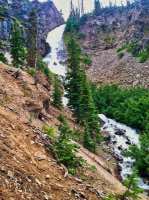
Following the Cascades, continue heading up the Creek for another ½ mile. Along the way, be sure to glance up occasionally, and I mean up, like up towards the sky. As you approach Upper Whychus Falls, you will be able to see the upper part of the falls come flying off a ledge at what seems way above where you would expect to see anything like that. As you approach, the trail will dive down towards the creek bottom. Follow it down to get your best view of this amazing waterfall. Upper Whychus Falls crashes down over 200 feet into the canyon below, bouncing off the side of a cliff and twisting on the way down. It is truly a spectacular falls and well worth the added effort to reach.
If you are an experienced route finder, really like waterfalls, and don’t mind spending the next several hours climbing over 3 billion downed trees, there are a number of other beautiful falls in the vicinity. There are two easily viewable falls on Park Creek and the South Fork of Whychus Creek has 3 falls in close proximity to each other, but they are not as easily viewable. Just be sure that you are experienced in open country travel through burned areas before heading out, because if something happens to you, I’m pretty sure Search and Rescue will just let you die rather than trying to carry you out of that hell hole of match-sticked timber. Enjoy!!
Directions
From Sisters, head south on Elm Street at the signs directing you to Three Creek Lake and follow the road for about 7 miles. From there, you will see a sign directing you to Whychus Creek, so make a right on the graveled forest road NF-1514. Continue along the road for almost 3.5 miles until you see a bridge heading over Whychus Creek and a kind of camping area along the stream. From there, before you cross the bridge, a two-track road will head up the creek for about a mile where you will find the trailhead.
Things to Know
Passes: Northwest Forest Pass is required at this trailhead.
Dogs: Allowed and must be on leash or under voice command at all times.
Usage: Moderate
Open Season: Road to the trailhead is usually snow-free by June.
Bugs: Mosquitos usually aren't too bad here but can be persent at certain times of the year.
Flowers: Most flowers will probably be blooming in June and early July.


