Cline Buttes Loop
Distance: 2.2 miles
Elevation Gain: 350 feet.
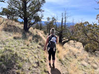
The Cline Buttes is a notable skyline feature as one gazes west towards the Cascades from Redmond. These three rounded peaks are the volcanic core of an ancient volcano that was formed around 25 million years ago and was actively spewing lava until about 5 million years ago covering about 5 square miles around the buttes. The southern peak is the highest of the three, but it is also the home to a federal aviation site. The Cline Buttes Loop can take you high upon a ridge of the northernmost hump, however, offering some stellar views of the Cascades and giving you an opportunity to flex those hiking muscles during the off season.
The trail begins at a small dirt parking area deep in the residential confines of Eagle Crest Resort. There are some signs and a trail map marking the start of the hike, so just do what they tell you to. The trail starts off climbing right away but is never really too steep. You will enjoy numerous switchbacks as you work your way up the northern flank of the butte, passing through some ancient juniper and rocky outcrops.
It only takes 2/3 of a mile to reach the high point of the hike. Here, you will be afforded some panoramic views of the Cascades, and there is even a peak finder so you can educate yourself on which ones are which.
Continue along the trail here as is makes its way back down the Cline Buttes. You seen to pass right by the back yards of some pretty cool houses. You will also pass an interesting rock (structure, pile, memorial, you pick the right word) full of painted rocks and some flags. The trail continues winding down the buttes, behind the homes, until it pops you out on Highland View Loop.
Once you hit the paved road, make a left and head towards the next street to your left. From there, you will be able to see a grassy common area heading behind the homes. Head for that and hop on a nice, paved path as it follows a pretty creek. There is also some nice shade along this path, a welcome break from the more exposed trail itself. After about half a mile on the paved section, you will cross over another road and hit a four way trail intersection. Make a right and follow a wide trail under the powerlines as it makes a bee line back towards the trailhead.
Directions
Finding the Cline Buttes Loop trailhead can be a little tricky, but following these point by point instructions will never let you down. Begin by heading west of Redmond on Highway 126 towards Sisters. Or, if you are coming from Sisters, then go towards Redmond. Because its between the two and that’s how geography works.
About 7 miles west of Redmond, you will turn south onto Eagle Crest Blvd into Eagle Crest. While there are other entrances into Eagle Crest from the Cline Buttes Highway, those require a resident’s key card, where this one is open to the public. Continue of Eagle Crest Blvd as it winds through the Juniper for 1.2 miles until you reach your first intersection. Then, make a right onto William Lyche Drive. Continue on for another 0.6 miles, past the Lakeside Sports Center and a small lake until you reach a four way intersection. Here, make a right onto Highland View Loop. You may think that my directions are whack as you come to a Highland View Loop that is not at a four way intersection. But it is called a loop for a reason and that is the wrong end, so trust me and continue on for just a few hundred more feet to the right end.
Once on the right Highland View Loop, just head up the road 0.1 miles until you see the parking area on the left just past the powerlines. You may feel like you are trespassing and keep looking over your shoulder as you drive in, but access is allowed, for now…….. So don’t squander you chance.
Things to Know
Passes:No passes are required
Dogs: Allowed and must be on leash
Usage: Light
Open Season: Area is open year round. Don't be shocked to maybe see some snow in the winter, and the trail can get very hot and dusty in the summer.