Devils Lake
Length: 1.1 mile
Elevation Gain: 150 feet.
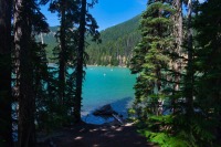
Devils Lake is a beautiful little, 23 acres lake located right along the Cascade Lakes Highway in Central Oregon. This shallow lake has an average depth of only 3 feet and reaches just 10 feet at its deepest point. The lake was formed when a lava flow dammed up the lake at its east end. Probably the most memorable quality about Devils Lake is its color. Its deep turquoise color is very eye catching as you first spot it off the side of the highway. And, lucky for you, there is a short trail that hugs the south side of the lake, allowing you to explore all the little secret areas of this gem.
The trailhead for the Devils Lake trail is located at the Devils Lake parking area. Several other trails take off from this spot, just as the South Sister climb, and Devils Lake itself is a popular attraction for boating and fishing, so it is likely to be busy. Luckily, much fewer people take advantage of the trail, so you will probably be able to find some peace and solitude as you move away from the trailhead.
Look for some trails heading out of the east end of the parking area towards the lake. Tings can kind of get confusing at first, because there are different trails heading all over the place. The campground at Devils Lake is walk in, so most of the other trails are heading off to camping spots. There is also a loop from the northeast section of the parking area that just loops through the campground. The trail you are looking for begins just south of the parking area loop, heading east. Once you are on it, if you see a fork in the trail, keep heading to your right, away from the lake. Soon, you will be past the camping areas and the trail will shrink to a normal, single track trail type.
As you pass the final camping spots, you will round a cool little cove and day use are of the lake. This is an easy spot to get right up in the water if you choose. Following this, the trail bumps up and sidehills along the lake until its eastern shore, and is usually 10 or 15 feet above the lake or so. As you head east, the color of the lake begins to change to that beautiful turquoise. You will also find yourself in a thicker forest, offering some nice shade.
The Devil’s Lake Trail only takes about half a mile to reach the far eastern shore of the lake. Here, looking across the highway, you can see the jumbled mass of lava that helped create this lake. There is also a nice marshy area here, as the water soaks into the ground only to pop out again towards Sparks Lake. The trail continues past lake for a little bit, but it will only pop you out up on the highway, so there is no need to go further. So make your peace with the lake fairies and head on back.
Directions
To reach the Devil’s Lake trailhead, head south on Century Drive in Bend towards Mt Bachelor. Remain on the highway past the mountain for about 7 miles until you reach the brilliant turquoise water of Devil’s Lake. The parking area is just past the lake on the left side of the road.
Things to Know
Passes: A Northwest Forest Pass is required at this trailhead.
Dogs: Dogs are required to be on leash or under voice control at all times.
Usage: Devils Lake itself and the trailhead will see heavy use, but light use on the trail itself.
Open Season: The Cascades Lake Highway usually opens around Memorial Day. The trail should be snow free by mid June.
Bugs: Mosquitos will likey be present during the snowmelt, likely June into early July, but will largely clear out after that.