Dry River Canyon
Distance: 4.9 miles.
Elevation Gain: 420 feet.
During the last Ice Age, a large lake encompassed much of the Millican Valley, where the towns of Millican and Brothers now reside. A river drained that lake and flowed through much of what is now the Oregon Badlands on its way to the Crooked River. While that lake and river are now long gone, you can still hike along its path and see where it carved its way through a 300 foot deep canyon as it rounded Horse Ridge.
The Dry River Canyon Trail begins at the end of a dirt road located just on the far side of a gravel pit about 17 miles east of Bend. The road is pretty sandy and in not too bad of shape (for a BLM road), but there are several larger rocks in the road that would lake driving it in something with less clearance than a Subaru challenging. If you don’t want to chance it, you can always park at the gravel pit and hike the road, it is less than half a mile to the trailhead.
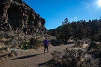
From the trailhead, the Dry River Canyon trail quickly drops down into the canyon bottom. The basalt walls won’t be too tall at first, but will continue to rise above you and you proceed deeper into canyon. The ground can be very sandy during the drier months, but will start to firm up as the winter rains begin to fall. You will also find yourself stepping over lots of rocks and ducking under branches along the trail, so be sure to limber up those joints.
About a mile into the trail, you will be fully immersed in the canyon. The rock walls have lots of different, cool formations on them. Some look like consolidated piles or rubble, others have streaks of red basalt, and even more are covered in lichen that is so green it almost seems to glow. /p>
The Dry River Canyon will continue mostly southward for the majority of the trail, slowly winding back and forth. As you near the end of the hike, you will first see the canyon turning sharply to the left. The shear canyon walls ahead of you will be covered with lichen. The trail will pop up and down some small, steep areas here and dive into some thicker vegetation.
Continue pushing through and the canyon will then turn sharply to the right, creating a horseshoe. Once you round the bend, you will find the canyon bottom covered in a massive boulder field. You can continue to pick your way through it if you wish, but the canyon peters out pretty quickly following the boulder field. Most people choose to turn around here.
Before you head to the Dry River Canyon, also make sure to make note of the date. This area is closed from February 1st through August 31st for nesting raptors. So, if you find yourself in the Fall or Winter, head on out this way and enjoy the scenery.
Directions
Head east on Highway 20 about 15 miles from the intersection of 27th Street. You will then make a left on Horse Ridge Frontage Road at a sign directing you into the Oregon Badlands Wilderness. As soon as you make the turn, head right into the gravel pit. Drive straight through the pit to the far side and you will see a road leaving the pit along with a gate and a sign letting you know if the area is open or closed. If you have a vehicle capable of clearing rocks in the road (about 6 inches or so), continue half a mile down the dirt road to the trailhead. If you don't, you can park here and walk the extra distance.
Things to Know
Passes: No passes are required.
Dogs: Allowed and must be on leash or under voice command at all times.
Usage: Light
Open Season: September 1st - January 31st. Area is closed in the spring and summer for raptor nesting.


