La Pine State Park - Fall River Loop
Distance: 4.75 miles
Elevation Gain: 250 feet.
The Fall River Trail offers you some beautiful vistas overlooking both the Deschutes and Fall Rivers as it meanders through some of the more remote sections of La Pine State Park. The park encompasses more than 2,000 acres north of La Pine and offers numerous activates in the sub-alpine forest, such as mountain biking, horseback riding, and boating. There are also over 15 miles of hiking trails located within the park.
To begin you hike along the Fall River trail, you don’t actually need to head into the park, proper. The best place to begin your trek is at the parking area on the northern boundary of the park. Here you will find a nice vault toilet and you will begin your hike right on the banks of the Fall River. The Fall River is a magical little stream, emerging full formed from a spring and flowing a mere 12 miles before emptying in the Deschutes.
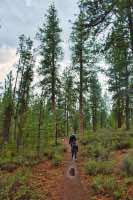
To begin your hike, you must decide if you’re the type of person you likes all the good things in life now and save the slogging for last, or you like to get the crap in life over with first and save the best for last. The loop, as it is described below, saves the best for last. So begin your hike by heading south on the trail that is at the east end of the parking lot. You will tromp through almost two miles of lodgepole and Ponderosa Pine without much more to look at. The hike is remarkedly flat, with just a few ups and downs over small hills as you go. You will also pass over a few forest roads from time to time, but the park does a good job of placing signs at those crossing directing you along the correct path.
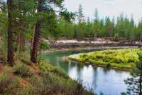
After about 1.1 miles from the trailhead, you will encounter your first trial junction. Remain on the Fall River trail as it swings to the west and then continues to the south. In less than a half mile from then, you will start to approach the main road entering the park and will see the entrance gate ahead of you. A little bit before you reach the road, the trail will turn back to the east and start heading towards the McGregor Viewpoint. You will cross over the road heading towards the viewpoint and then the trail will swing to the north as it approaches the river. This spot offers a nice overlook of a sharp bend in the Deschutes with Paulina Peak looming in the background.
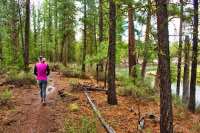
Continue on the trail as it follows the river downstream for less than a ¼ mile. At this intersection, continue to follow the Fall River trail to the left as it re-enters the forest and cuts off a couple large meanders of the river and avoids a small neighborhood. In about ¾ of a mile, you will find yourself back on the banks of the Deschutes as it winds its way through some slow moving, swampy meadows. In a little more than half a mile, you will near the confluence of the Fall River and the Deschutes. Here, the trail cuts off that corner and heads straight for the Fall River. Mosey along these banks for another ½ mile until you see the sign directing you to the falls. Follow this trail to your right for about 500 feet of so to a nice overlook of the small, 10-foot falls. Once your viewing is complete, or the small bird sized La Pine mosquitos have chased you off, head back to the intersection with the main trail, and continue along the final half a mile back to your vehicle.
Directions
Take Highway 97 seventeen miles south of Bend and make a right onto Vandevert Road. There will be signs here directing you to Fall River and Cascade Lakes Highway. Continue on Vandvert Road for a mile and then make a left onto South Century Drive. After 1.1 miles, South Century Drive will head to your right. Continue following this road. Just follow the scenic drive signs. After another 5 miles along South Century Drive, and bridges over both the Little Deschutes and Deschutes River itself, make a left onto an unmarked gravel road. Pass by the first parking area and head over the river. The trailhead will be on your left.
Things to Know
Passes: No passes required.
Dogs: Allowed and must be on leash.
Usage: Moderate
Open Season: Accessable all year but will likely be snow covered during the winter.
Bugs: Mosquitos around La Pine suck. Count on them being there, especially in the spring and early summer.