Freezeout Saddle
Length: 5.6 miles
Elevation Gain: 1,800 feet.
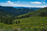
Hells Canyon is the deepest river gorge in North America at nearly 8,000 feet. At its deepest, the Snake River carves its way over a mile below Oregon’s western rim and 7,400 feet below Idaho’s Seven Devils Mountains. The trail up to Freezeout Saddle, the lowest point along the Oregon rim, allows one to stand on the edge of this national treasure.
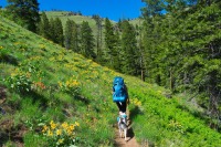
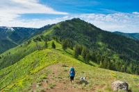
Begin your hike from the Freezeout Trailhead just off the Imnaha River. There will be two trails leaving the parking area, both out of the western side. You will want to take the left trail, also known as the Saddle Creek Trail. And get ready to climb. This trail doesn’t mess around. It is 2.8 miles to Freezeout Saddle and you will climb 1,800 feet in that time. The trail heads up and around ridges and endlessly switchbacks as it makes its way up the saddle.
After a little more than half a mile, you will dive into some trees and encounter Saddle Gulch Creek. It is a fairly small creek and has a log to walk over to get across. But in just a few hundred feet, you will have to cross back over. Again, there are some rock hopping options and you should be able to keep your feet dry.
Depending on the time of year, the wildflowers found along the hillside as you climb up Freezeout Saddle can be absolutely breathtaking. Blue Dicks, Balsamroot, paintbrush, and biscuitroot can be seen everywhere. It will help take your mind away from your poor, aching legs.
Once you reach Freezeout Saddle, you can finally stop and really enjoy the view. Straight ahead, Hells Canyon drops away from you, falling more than 4,000 feet down to the Snake River below. The Seven Devils can be rising at the far side of the canyon. The western rim of Hells Canyon snake away both to the north and south. If you turn around, the snow covered (if it is earlier than late summer) Wallowas dominate the skyline.
Directions
From Joseph, head east on Highway 350 for 30 miles until you reach the small town on Imnaha. Head right on Upper Imnaha Rd for 12.4 miles. Right before crossing a bridge over the Imnaha River, take NF-4230 to the left. Follow this narrow road for 2.7 miles and the trailhead will be at the end of the road.
The trailhead can also be reached from the south, if you are coming from the Baker City area. Head east on Highway 86 for 63 miles from Baker City, until you reach the Wallowa Mountain Loop road. There will be a sign directing you to Joseph here as you make the left. This road is usually closed until sometime around Memorial Day, so plan accordingly. Follow this paved road for 25 miles until the Upper Imnaha Road branches to the right. This is a large, gravel road that is riddled with craters. (Some say potholes but they seemed much larger than that to me.). Follow this road for about 18 miles, crossing the river 3 times on your way to the trailhead. Just after the third bridge, take a right onto NF-4230 and continue 2.7 miles to the end of the road.
Things to Know
Passes: A northwest Forest Pass is required at this trailhead.
Dogs: Allowed and must be on leash or under voice command at all times.
Usage: Light.
Open Season: Because of its low elevation, Freezeout Trailhead offers some of the earliest season access into Hells Canyon. The trailhead is usually asseciable in April. However, expect snow on the upper elevation trails into June.
Flowers: May and June tend to be the best wildflower months, with different elevations blooming as the seasons progress.
Hazards: Ticks and Rattlesnakes are prevelant in this areas during the right times of the year. There are also lots of bear in the area, so if you are backpacking, use proper precautions.