Hells Canyon - Freezeout Saddle to Mark's Cabin Loop
Length: 11.4 miles
Elevation Gain: 3,225 feet.
Hells Canyon is the deepest river gorge in North America at nearly 8,000 feet. At its deepest, the Snake River carves its way over a mile below Oregon’s western rim and 7,400 feet below Idaho’s Seven Devils Mountains. The trail up to Freezeout Saddle, the lowest point along the Oregon rim, allows one to stand on the rim of this national treasure. And the trail from there to Mark’s Cabin lets you continue to climb as you march along the western rim.
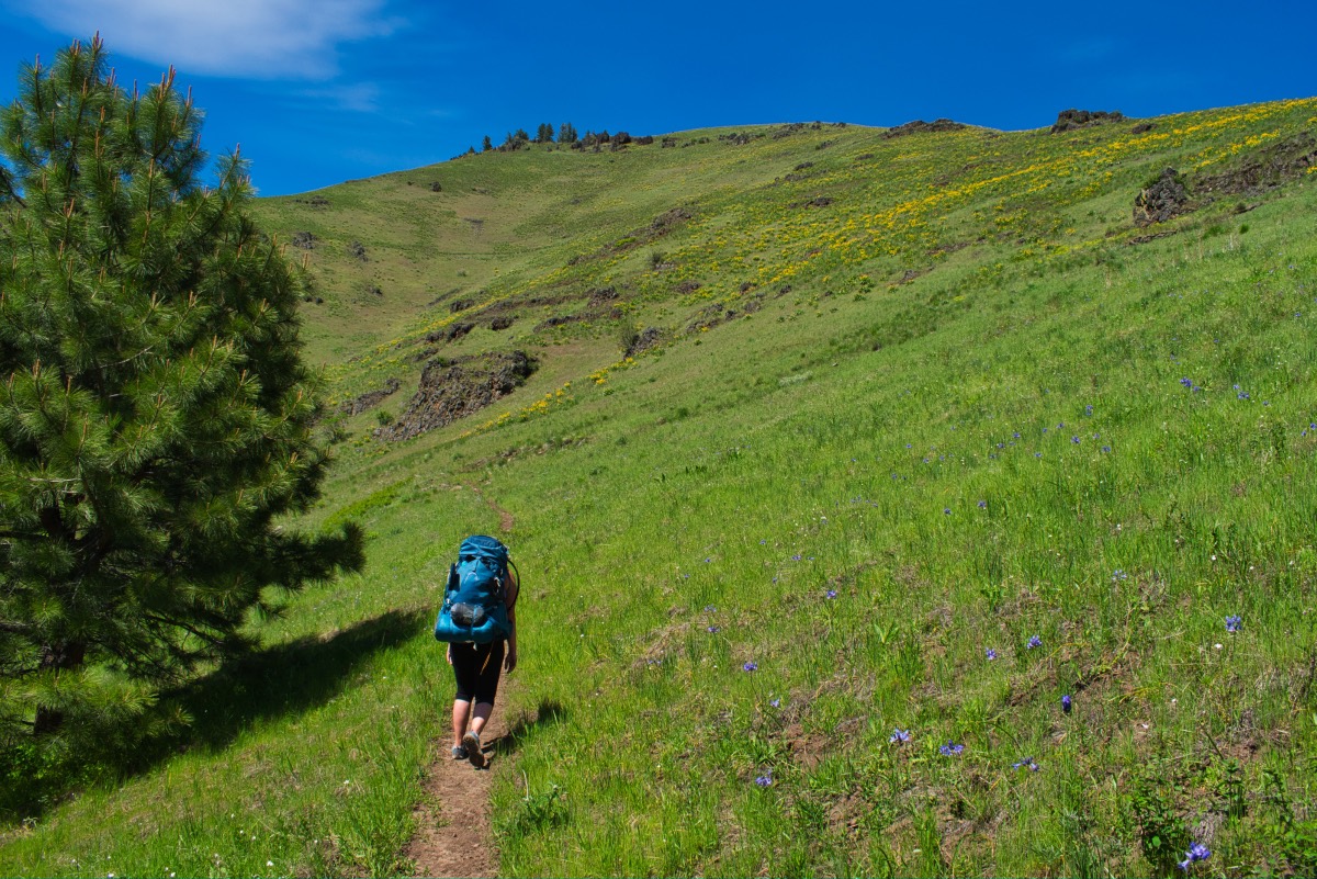
Begin your hike from the Freezeout Trailhead just off the Imnaha River. There will be two trails leaving the parking area, both out of the western side. You will want to take the left trail, also known as the Saddle Creek Trail. And get ready to climb. This trail doesn’t mess around. It is 2.8 miles to Freezeout Saddle and you will climb 2,000 feet in that time. The trail heads up and around ridges and endlessly switchbacks as it makes its way up the saddle.
After a little more than half a mile, you will dive into some trees and encounter Saddle Gulch Creek. It is a fairly small creek and has a log to walk over to get across. But in just a few hundred feet, you will have to cross back over. Again, there are some rock hopping options and you should be able to keep your feet dry.
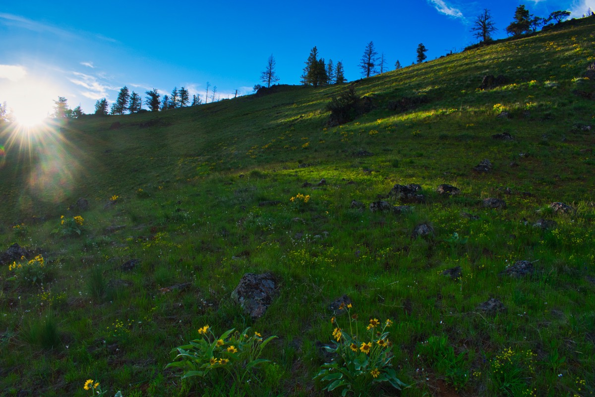
Depending on the time of year, the wildflowers found along the hillside as you climb up Freezeout Saddle can be absolutely breathtaking. Blue Dicks, Balsamroot, paintbrush, and biscuitroot can be seen everywhere. It will help take your mind away from your poor, aching legs.
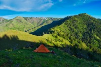
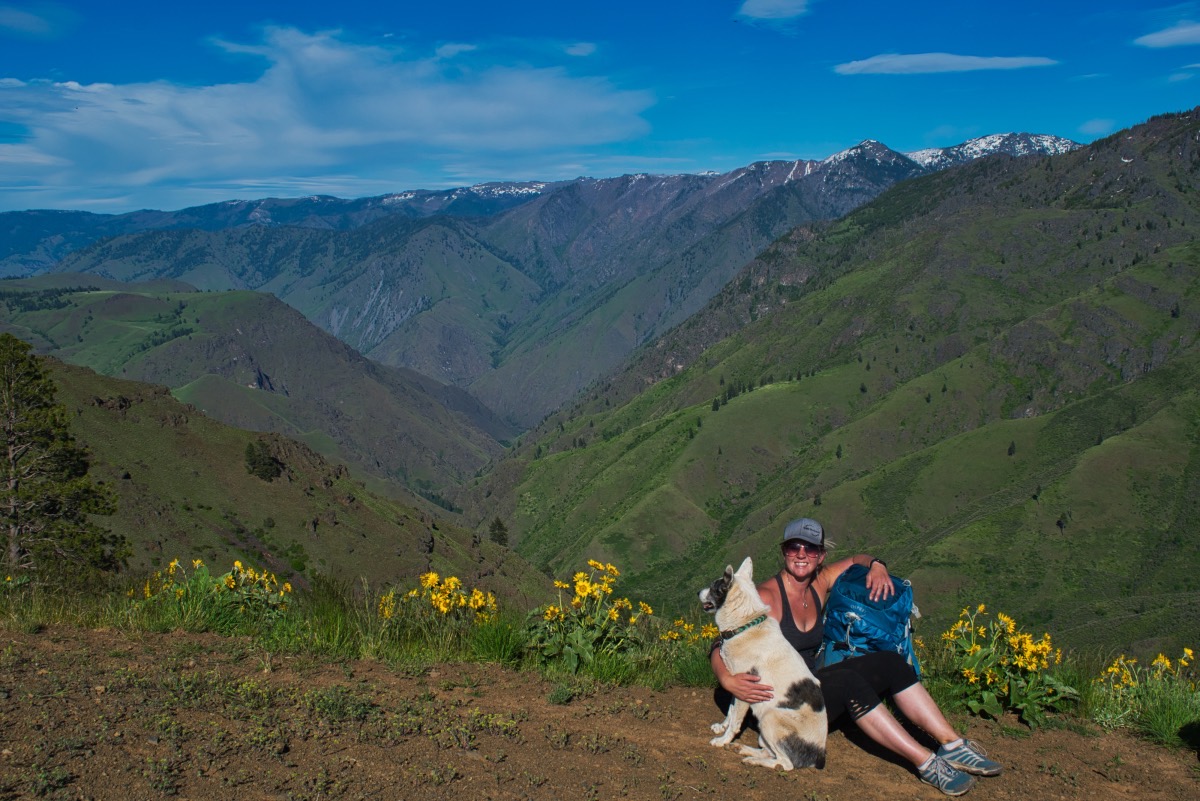
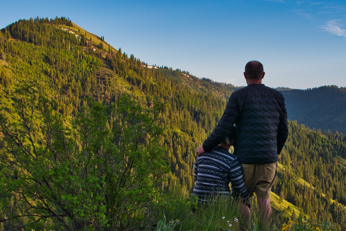
Once you finally reach Freezeout Saddle, you can finally stop and really enjoy the view. In front of you, Hells Canyon drops away from you, falling more than 4,000 feet down to the Snake River below. The Seven Devils can be rising at the far side of the canyon. The western rim of Hells Canyon snake away both to the north and south. If you turn around, the snow covered (if it is earlier than late summer) Wallowas dominate the skyline.
Once you are ready to move on, head to your right and start heading south along the rim. The trail drops below the rim as to traverses around a high point and reenters the forest. This section of trail had a number of trees down across it, and I don’t think it is the recipient of a ton of maintenance. And the trees down across it aren’t nice, clean logs. They are the whole brushy tree with branches everywhere. It can be challenging getting through.
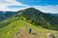
The trail continues to climb for about the next 3 miles, but at a much slower pace than before. You will emerge from the trees about 1.25 miles from the saddle and 400 feet below the canyon rim. You will find yourself on an open, grassy hillside that falls steeply away. Continue along the trail as it traverses the hillside, climbing towards the rim. About a half mile after emerging from the forest, the trail will head over a small ridge and into a large bowl. On the north side of that ridge, there is a snowfield that likes to linger into June some years. Try to work your away around the snow if you can, or be very cautious crossing it. The terrain is very steep here and if you started sliding down the snow, you may not be able to stop yourself when you slide off it.
After crossing the ridge, you have your final ¾ of a mile push, climbing the last 500 feet to the west rim again. Once up, rejoice, your done climbing!! You stay a little bit west of the actual rim, so you won’t be able to see into Hells Canyon unless you go looking for a view. After about half a mile along the top, you will come to a trail junction. Both directions will get you to the same place in about the same distance. If you stay on the Western Rim Trail, taking the left trail, you will have some slightly better views, as the trial drops into the Hells Canyon side of the rim. You will head up Saddle Creek and have the Bear Mountain Ridge across from you to hold your interest and you will find yourself trudging through squirrel prairie. The downfall of this path is that once you hit the intersection with the Black Mountain Trail, you will have to march 200 feet back up the rim. If you don’t feel like climbing anymore, head right on the Mark’s Cabin Trail.
Mark’s Cabin Trail remains on the western side of the rim as it works its way around a large knoll. This trail can be hard to follow in places, and can be some of the last holdouts of snow in the area. While there isn’t any sketchy side hilling on snow covered slopes with 2000 feet of tumbling below you, you are in some pretty think woods here, and when the trail is buried in snow, it can be very hard to follow. If you choose this route and are hiking at a time of year when you may encounter snow, be sure to have a good GPS with the trail loaded in so you don’t end up somewhere you really don’t want to be.
On the Mark’s Cabin Trail, you will leave the forest about a mile from the junction with the West Rim Trail. You will find yourself on a grassy knoll (yup, I said it), as the hillside bends around to your left. And the trail just seems to disappear here. The actual trail heads straight, heading down the mountain for a little bit, and then swings to the left. There will be a whole bunch of downed trees to your left and the trail travels below them. There will also be a fence on the edge of the grassy area. The trail will go through a break in it. If you are climbing over the fence you are not on the trail.
After traveling through the fence, you will encounter the Freezeout trail in about ¼ of a mile. The trail junction isn’t marked and the Freezeout Trail can be hard to see. We encountered a small snowmelt creek running down it and totally missed it at first. It didn’t really look like a trail and the trail moving forward is mostly overgrown with grass and isn’t very noticeable either. So keep your eyes open.
If you want, you can continue up the Mark’s Cabin trail for a few hundred feet to Mark’s Cabin. You can’t really do anything at this private cabin, but it is pretty cool seeing a functioning structure this deep in the wilderness. There is also a spring development with a spring filling a trough here, if you need water.
Once you start heading down the Freezeout Trail, you will start to hate downhills almost as much as ups as you drop 2,000 feet in the next 2 miles. The trail continues through some beautiful meadows and stringers of forest. There aren’t as many switchbacks along this trail. It is just flat out steep.
As you get lower, the trail will start to get wider and wider, as more livestock and horses make use of it. The soil along the trail likes to hold its deformation it experienced when it was wet, so watch out for hoof prints concreted into the ground. The surface isn’t the smoothest for most the way down.
After a couple of miles, you will come to an unnamed creek that, depending on the time of year, you may have to ford across. Once across, you have a small climb ahead of you as you round another ridge. Flowers can abound here and the view across Freezeout Creek to Morgan Ridge on the other side is beautiful.
Once around the knoll, you still have a steep, almost 1000 foot drop ahead of you. It seems like this section may also be used to drive cattle as the trail becomes very wide and beat up. Once down, you will hit one more intersection, with the Morgan Ridge Trail heading left. You want to go right and continue on the Freezeout Trail. You only have one obstacle left. Just before reaching the trailhead, Freezeout Creek has migrated into the trail, and the part of the creek that overruns the trail looks very deep and swift. There is a small, user trail that heads up through the brush around the washout, but it requires a little scrambling. After this, you will be back at the trailhead in no time. Hug your car. You will be excited to see it.
Directions
From Joseph, head east on Highway 350 for 30 miles until you reach the small town on Imnaha. Head right on Upper Imnaha Rd for 12.4 miles. Right before crossing a bridge over the Imnaha River, take NF-4230 to the left. Follow this narrow road for 2.7 miles and the trailhead will be at the end of the road.
The trailhead can also be reached from the south, if you are coming from the Baker City area. Head east on Highway 86 for 63 miles from Baker City, until you reach the Wallowa Mountain Loop road. There will be a sign directing you to Joseph here as you make the left. This road is usually closed until sometime around Memorial Day, so plan accordingly. Follow this paved road for 25 miles until the Upper Imnaha Road branched to the right. This is a large, gravel road that is riddled with craters. (Some say potholes but they seemed much larger than that to me.). Follow this road for about 18 miles, crossing the river 3 times on your way to the trailhead. Just after the third bridge, take a right onto NF-4230 and continue 2.7 miles to the end of the road.
Things to Know
Passes: A northwest Forest Pass is required at this trailhead.
Dogs: Allowed and must be on leash or under voice command at all times.
Usage: Light.
Open Season: Because of its low elevation, Freezeout Trailhead offers some of the earliest season access into Hells Canyon. The trailhead is usually asseciable in April. However, expect snow on the upper elevation trails into June.
Flowers: May and June tend to be the best wildflower months, with different elevations blooming as the seasons progress.
Hazards: Ticks and Rattlesnakes are prevelant in this areas during the right times of the year. There are also lots of bear in the area, so if you are backpacking, use proper precautions.