Lava Cast Forest
Length: 1.0 mile
Elevation Gain: 90 feet.
Deep in the Ponderosa Pine Forest east of Sunriver lies countless flows of lava as they occasionally burst from the flank of the Newberry Volcano. The Lava Cast Forest Trail leads you on a journey through one of these flows. The Newberry Volcanic National Monument houses one of the largest volcanoes in North America, the Newberry Volcano. This giant shield volcano is responsible for more than 400 cinder cones and 1,300 square miles of lava flows throughout the Deschutes National Forest. The Lava Cast Forest Trail is a great opportunity to view on of these flows up close, and witness the effects of the flow locked in time.
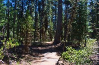
The Lava Cast Forest trail begins from the day use interpretive site of the same name. There is a small parking lot along with a picnic area situated among the trees. The trail leaves out of the east end of the parking area near some kiosks. The trail is paved for its entirety, and the first half of it is wide enough to accommodate wheel chairs.
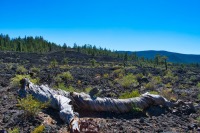
The trail climbs quickly, marching up about 30 feet out of the trees and into the lava flow. What you see before you occurred 6,000 years ago, when the Newberry Volcano erupted along a series of fissures on its northwest flank. Smooth flowing lava flows, known as pahoehoe lava, surged through the area, engulfing the forest before it.
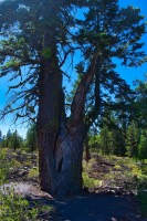
As the trail winds through the lava, there are numerous interpretive signs describing some of the things you are observing. One of the coolest are the tree molds. Here, the lava flowed around trees that were standing at the time. As the lava engulfed the tree, it cooled before the tree could burn away, leaving a mold of the trunk through the lava to the ground below. There are also some good examples of the twisted trees that grow in nutrient poor areas like the lava.
The trail heads out into the lava for about half a mile before reaching a point where you can stare towards Newberry and see what looks like miles of lava ahead of you. Then it loops on back to where you started. While the hike is easy, there aren’t many examples of geography such as this you can witness other places in the world. So soak it all in.
Directions
To reach the Lava Cast Forest trailhead, take exit 153 on S Century Dive towards Sunriver form Highway 97. There will be sings directing you to the Lava Cast Forest from here. Follow the signs directions and head east, under the highway from the exit. Follow this road for 9.2 miles until you reach the trailhead. The road turns to gravel quickly, but is in really good shape and most vehicles should be able to make the trip.
Things to Know
Passes: Northwest Forest Pass is required at the parking area of the visitor center.
Dogs: Allowed but must be kept on leash
Usage: Light
Open Season: The trail and access road will likely be snow free from May through October, but this can vary by year.


