Paulina Peak
Paulina Peak marks what is left of the summit of the Newberry Volcano and towers over Paulina and East Lakes below, reigning supreme within the Newberry National Volcanic Monument. Newberry Volcano is a shield volcano that covers over 1,200 square miles, making it the largest volcano in the Cascades. It’s shield shape, however, makes it appear more as a long ridge rather the steep sided stratocones common to the west. The majority of eruptions occurring on Newberry consisted of a more fluid lava, like those found in Hawaii, slowly building the volcano in layers. A more violent eruption did occur about 75,000 years ago, creating the Caldera containing both East and Paulina Lakes.
You begin your climb up Paulina Peak from one of two trailheads. If you are looking for a couple more miles and a little more vertical, start from the Paulina Lake Trailhead across from the visitor center. If you don’t mind skipping the couple of miles of strolling through the woods, you can head about a mile up the Paulina Peak road until you reach the Paulina Peak Trailhead. The real meat of the hike begins here.
If you’ve started from the lower trailhead, head across the street towards the visitor center and look form assign directing you to the Crater Rim Trail, heading towards the west. You will find yourself on a nice, easy trial as it winds through the woods up towards the upper trailhead. After a quick mile, you will reach the trailhead as you cross the Paulina Peak road. If you are beginning your hike here, look for the kiosks and signs across the road to begin your hike up the peak.
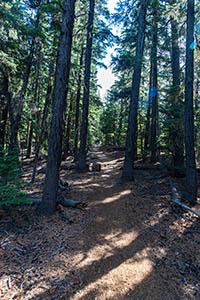
Once across the road, the trail begins to climb. There is a short, steep pitch right off the bat as you begin the climb the western ridge of the north bowl. After that first pitch, you will have a fairly gradual uphill climb for the next half mile. The ground will continue to drop away from you on your left as you climb up the ridgeline. Then things get interesting. And by interesting, I mean steep.
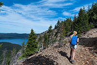
Prepare to climb about 700 feet in the next 0.7 miles as you climb up the ridge. Things won’t be very exciting at first, as it is just a steep hike in the woods. But soon the trail will start to swing to the left and you will find yourself standing on the rim of the northern bowl. The view is pretty awesome as the mountain drops away in a treeless slope with pinnacles of obsidian jutting from the mountainside. The trail remains along this rim for about a tenth of a mile, offering you plenty of vistas, before diving back into the woods.
The trail will begin to mellow out about half a mile from the overlook, and the vegetation will become sparser and more open, with Whitebark Pine dominating the landscape. These trees are common in some of the subalpine areas of the Cascades and can live for over 1,000 years. You will again approach the edge of the bowl as the trail slowly climbs to the summit. The views down the dizzyingly steep slope below you with its pinnacle guardians is pretty spectacular.
About half a mile further and you will find yourself on the top of Paulina Peak. Well, almost. You will find yourself in a small parking area, which is weird to find on the top of a mountain. The view is spectacular with Paulina and East Lakes laid out below you and the obsidian flow appearing to ooze right towards them. The cascades can be seen in all their glory to the west. The actual summit of the mountain is on the western side of the parking area and is just a shot little scamper up, just in case you want to say you made it to the very top.
Directions
To reach the Paulina Peak trailhead within the Newberry National Volcanic Monument head 23 miles south of Bend or 6 miles north of La Pine on Highway 97. Then, head west on Paulina Lake Road at the big signs directing you to Newberry Caldera and Paulina – East Lakes. Follow the road for 13 miles as it winds up the mountain. Pass by the Welcome Center and the trailhead for Paulina Falls. To reach the lower trailhead, take the left right after passing the road that takes you to the Paulina Lake Lodge, into the boating site. If you would prefer to start at the upper trailhead, take the Paulina Peak road on your right a quarter mile past the visitor center. Continue on this paved road (except for the last quarter mile or so, which is a nice gravel road) for a mile and the trailhead will be on the right.
Things to Know
Passes:A Northwest Forest Pass is required at this trailhead.
Dogs: Allowed and must be on a leash.
Usage: Moderate
Open Season: The road up to Paulina Lake closes in the winter at 10-mile Snopark, 10 miles from the highway. It usually opens for the season in late May and closes in Mid Novemeber. There could be snow on the trail well into July.
Bugs: Mosquitos will likey be present and persistent from late May into the middle of July or so.


