Painted Canyon Loop
Length: 9.1 miles
Elevation Gain: 1,200 feet.
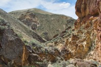
The Painted Canyon Loop is a beautiful trek through some of the most remote sections of Oregon. The hike will take you past towering obelisks, sheer cliff walls, and lots of honeycomb formations. This is not a hike for beginners, however. These is no “trail” as you will be following roads, cattle trails, and dry washes for the majority of the hike. You will even just be hiking overland through the sagebrush for a mile or so. Route finding is a required skill as you will need to know when to enter and exit the Painted Canyon. Climbing down large boulders that clog draw and over dry waterfalls are also necessary. If you are not well versed in these skills, you could become lost or injured where you have no cell phone coverage, there is absolutely no water to be found, and are in a location so remote, you are not likely to see a single other soul on your hike. If you are confident in your abilities, this is more of an adventure than a hike and you will be privy to some of the most dazzling scenery in Oregon.
You will begin your hike at the site of an old, round cattle trough just off a nothing road in the middle of nowhere (There is no trailhead because there is no trail. The directions sections will have more detail on the lovely road.). Start your adventure by heading south on the road for about a quarter of a mile. Here, you will find yourself within a draw that is the upper end of Carlton Canyon.
Turn down Carlton Canyon and begin your overland adventure. At first, the canyon is more of a small valley, and there isn’t much of streambed to follow. There are the occasional cattle trail, but they seem to wander all over and just disappear into the sagebrush. But take solace in the fact that it is hard to get lost hiking down a canyon. Just keep heading downhill and you will be fine. The easiest way at this point is to just mosey (cause that’s what you do when you are in fields of sage) through the sagebrush until the canyon begins to narrow. You will also encounter a barbed wire fence that spans the canyon less than a mile from the start, but the wire is loose and easy to get through.
A little more than a mile from the trailhead, the canyon briefly narrows up as you wind your way past some large rocks in the valley bottom. After the constriction, the canyon widens out again, and the cattle must feel more confined at this point, because their trails become more defined and travel more consistently in the correct direction. You will continue down the canyon like this for another 2 miles until things start to get interesting.
A little past the 3 mile point of the hike, the canyon really narrows up and gets very steep. The sides are not vertical walls of rock, but the canyon is a deep V formation, and the bottom is clogged with car to house sized boulders. It will take a while to work your way down the next quarter mile or so, trying to find the best way around some of these 10-15 foot drops. Soon, you will work your way through this steep section and the canyon will turn sharply to the right. And as you round the corner, you will begin to see some of the rock that make up Painted Canyon.
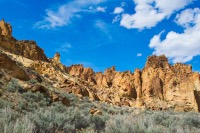
You will continue to follow the sandy bottom of Carlton Canyon for the next mile. The scenery in this section of the canyon is vastly improved, however. The cliff walls are steep and beautifully colored and towers, hundreds of feet high, line the canyon walls. A half mile along this stretch, there will be a huge amphitheater on the right. The canyon will make a slow, continual bend to your left for a while, before turning more sharply to the right. Once you make the right and begin heading due west, watch for a large tower followed by a thin fin of tuff sticking out into the canyon from the right. The entrance to Painted Canyon will be the first large canyon on your right you come to after that turn, and is located just past that narrow fin on this straight stretch.
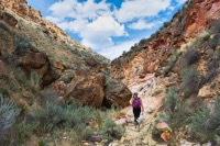
Once you turn right (to the north), you will officially enter beautiful Painted Canyon. Here, vertical cliffs of many shades of color make up the canyon walls. Towers, obelisks, and honeycombing abound. The easiest route up the canyon is to follow the sandy wash that winds its way along the canyon floor. It is usually fairly wide and free of vegetation. The wash is very sandy however, and after 3 miles of gradual uphill in what feels like walking on the beach, you will definitely start to feel the burn in your legs.
Hiking up a canyon is not quite as simple a matter as hiking down, because there will be lots of branches and side canyons where you can get lost if you take the incorrect route. You will encounter the first major canyon branch after a mile and a half from the mouth. Here you want to keep bearing right to remain in Painted Canyon. The canyon will veer to the east before turning back towards the northeast.
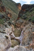
About 2 miles from the mouth, the canyon will begin to narrow up and you will enter the stepped section of the canyon. There are many boulder plugs and dry waterfalls over the next ¾ of a mile. Some of them you can skirt by heading around them up the sides of the canyon, but some require some serious scrambling. This is the section that is very difficult if your dog is with you. Our dog is half mountain goat and can seemingly run up vertical walls, and we still had to boost him up some of these. Luckily, none are much larger than 10 feet or so.
The trickiest part of the hike is finding where to leave Painted Canyon. After climbing up and over several steps, the canyon will start to flatten out some, with more hilled slopes than the vertical walls, but still with a deep, rock gully carved into the bottom. There is still the occasional rock jam to climb over. Once you start encountering terrain such as this, watch for a small draw entering from your right.
The best way to find this draw is to have a GPS with the route preloaded, because there really isn’t any defining characteristic. This draw is a steep, V-shape and only a few feet wide at the bottom. After entering the draw, you should only have to go a couple hundred feet. Then, if you look uphill to your left, you should be able to see a carbonite post at the top of the hill. Scramble up the steep hill and find yourself on a nice road. Now all you have to do is follow the road for 1.25 miles and you will have returned to your vehicle, safe and sound. Piece of cake, right?
Directions
Getting to the “trailhead” for the Painted Canyon Loop is almost as much of an adventure as the hike itself. There are no signs and road sucks for a good portion of the trip. And there are a lot of wrong roads you can take. I don’t know how many blogs I read about this hike where the authors never even found the trail. So listen closely, and I will be your Obi-Wan of directions.
First of all, make sure that you have a fairly high clearance, four-wheel drive vehicle. And if it has rained or could rain, don’t go. The roads can turn into undrivable slop if they are wet. With that in mind, head towards Adrian, a very small town south of Ontario on Highway 201. From Adrian, head south on 201 for 8.5 miles and, just before crossing into Idaho, make a right onto the wide gravel road that is Succor Creek Road.
Follow this road for the next 8.5 miles. Succor Creek road is in relatively good shape and is an easy drive. There aren’t any road markers out here, however, so watch your odometer. After 8.5 miles, you will want to make a right onto a two-track road called Camp Kettle Creek Road. (Again, there are no signs, so you won’t know this, but just trust me). The next 15 miles will be slow going, with steep, very rocky sections for your enjoyment.
Camp Kettle Creek Road is obviously the main road and easy to follow for the next 2.8 miles. Then, you will encounter a four-way intersection. You want to road that heads straight ahead, straight up the ridge that is in front of you. As you wind through the rocky outcrops near the top of the ridge, a couple of side roads will head off to your left, just stay right through these and you will be fine.
You will head down the ridge and pass over a small draw 1.2 miles from the four-way intersection, 4 miles from Succor Creek Road. After crossing the draw, another road will again head to your left. Stay right again. In another half a mile, the road will split again, with one road re-crossing the draw and heading up a hillside to the right. Stay left this time and remain in the valley.
Another half mile will have you crossing a larger draw. Another road will continue up the draw but you will want to stay left and cross over and then up and out of the draw. A quarter mile further one will take you over a cattle guard and you will find yourself at yet another intersection. Head to the right and continue your journey.
The road is easy to follow for the next 2 miles with no major intersections to worry about. When you do reach the next intersection, it will be with McIntyre Spring Road. Head to the left/straight on this road. You are getting closer!!
You will remain on McIntyre Spring road for 1.1 miles. There will be a couple side roads heading off to your left on this stretch, but just continue straight. At the 1.1 mile mark, you will want to bear right on an unnamed road, just before crossing another draw. Soon after starting up this road, it will Y. Take the left route and continue on.
Once on this unnamed road, there will be some side routes heading to the right at first, and then to the left, but you should be able to identify the main road fairly easy and continue on straight at those intersection. Finally, after another 2.9 miles, you will come to another 4-way intersection. To your left should be a cattle guard. Head left, over the cattle guard, and in less than half a mile, you should see the large, round cattle trough to your right. Pull in here. You made it!!!!!! Nothing to it. I think I have carpel tunnel from typing all this….
Things to Know
Passes: No passes are required.
Dogs: Allowed and must be on leash or under voice command at all times. There is no water on this hike and the rock climbing/scrambling can be very tricky with a dog, especially if they aren't the best climbers or are to heavy to hoist up the cliffs.
Usage: Light
Open Season: Open year round, but if it has rained or is wet, the roads in this area can become impassable. Also be aware of thunderstorms because flash floods in these canyons are aways a risk. The summers can get brutally hot.
Hazards: Hmmm, lets see. Rattlesnakes, heat, lack of water, no trail, cliffs, remoteness... There's a lot that can go wrong on this trail, so make sure your prepared. I don't want to have to deal with a lawsuit from your ghost lawyer cause you headed out here not knowing how to read a map and got lost, bit by a snake, fell off a cliff, swept downstream by a flash flood, and then died of dehydration. Ghost lawyers are jerks.