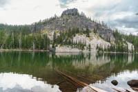
Rosary Lakes
Distance: 7.2 miles
Elevation Gain: 800 feet.
The Rosary Lakes are a string of three lakes situated along the eastern base of the Willamette Pass Ski Area. The lakes have been describes as resembling the beads of a Rosary, and the religious theme carries over to Pulpit Rock which overlooks the lakes and even Maiden Peak to the East. These lakes make a great place to relax and enjoy their serene beauty while idling the day away. (I’m practicing for a travel agent position there, but they really are pretty).
The hike begins from a well marked but kind of hard to find trailhead just east of the ski area. There will be a sign directing you to the Pacific Crest Trailhead off of the highway, but it seems to take you into an ODOT cinder yard with no parking signs everywhere. But belay your confusing and look to your right. Past the covered structure, you will see an opening in the trees and a vault toilet. This, my friends, is your trailhead.
The trail leaves the parking area from the north and quickly joins up with the Pacific Crest Trail. Here, you can expect a nice, slow, steady climb as you march up the flank of the ski area. The trees and thick and tell here, so don’t expect much for views, but you can see Odell Lake peaking through the forest on occasion. After about 2 miles and over 400 feet of climbing, the trail will round a shoulder and turn more northerly on the final stretch to the lakes.
Keep climbing through the woods for another half mile and you will find yourself at Lower Rosary Lake. This is the largest of the three lakes and Pulpit Rockdominates the skyline to the North. Don’t stop here though because there are two more lakes waiting for exploration.
The trail hugs the eastern shoreline of the lake as it makes its way around it. Once past the lake, the trail will enter the woods again and climb another 100 feet in a little less than half a mile on its way to Middle Rosary Lake. I feel the views from this pretty little lake are the best, with Pulpit Rock rising right out of the western shore.
Once you’ve had enough of Middle Rosary, follow the trail as it once again, hugs the eastern shore. The distance between Middle and Upper (or North Rosary Lake, depending on the map you are using) is much shorter though. There is a small saddle between the two lakes and they are close enough that you could probably throw a rock form one to the other, if you’ve got a good arm. From Upper Rosary, head towards the northern shore to get the best views.
Directions
The trailhead for Rosary Lakes can be found off of Highway 58, just a quarter mile east of the Willamette Pass Ski Area. A sign directing you the Pacific Crest Trailhead will be on the highway, pointing you to an ODOT Yard. Head into the yard and look to the right in front of the covered building to find the parking area and trailhead.
Things to Know
Passes:No passes are required
Dogs: Allowed and must be on leash or under voice control and all times.
Usage: Moderate.
Open Season: The trail can be accessed any timne during the year, but the trailhead becomes snowed in in the winter, requiring one to start from the ski area. There will likely be snow on the trail into June.
Bugs: Mosquitoes can be prety brutal year from June well into August.


