Blow, Doris, and Senoj Lakes
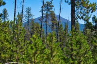
The Cascades Lakes of Central Oregon are known for many beautiful bodies of water, such as Sparks Lake, Elk Lake, Lava Lake, and more. However, for those willing to get off the highway and trek into the wilderness, there are more. Many, many more. You could even say countless more. There are some areas, where if you zoom in on some satellite photos, it seems like there is as much water as land.
The Six Lakes Trail, beginning near Elk Lake, is one gateway into this lake hunters paradise. The trail, as it is described here, will take you past three large, and beautiful lakes. Just be forewarned, all the water is this area comes with a consequence. If you plan on hiking this trail before about mid-August, you will be entering mosquito hell.
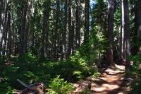
The trail leaves out of the western end of a large parking area. The first lake you will be heading towards is Blow Lake. The trail towards the lake is a steady, if gradual uphill. It parallels a small stream that mostly dries up later in the summer, but you may still find some flowers along its grassy banks. In a little more than a mile, you will find yourself on the southeastern end of Blow Lake.
Blow Lake covers about 50 acres and its deep blue water contrast beautifully with the green trees and some rocky outcrops on the far shore. It can be a nice place to take swim, but this lake does tend to have a steady breeze that blows across it, hence its name. If you visit the southeast shore, you will notice a fair amount of logs piled up there. I will leave it to you to figure out which way the wind blows.
After Blow Lake, the Six Lakes Trail continues climbing up towards Doris Lake. The forest changes after Blow Lake form predominately Lodgepole Pine to one more dominated my Mountain Hemlock and sub-alpine fir. This offers way more shade and, in my opinion, is much easier on the eyes. Occasional tufts of bear grass line the trail in sunny areas and there are some cool rock formations as well. In about 1.5 miles and 200 more feet of climbing, you will arrive on the shores of Doris Lake.
There are a couple of trail options as you pass by Doris Lake. There is a small loop that heads down near the southeastern shore, and a second spur that takes you to a cool little outcrop out over the southern shore. In both cases, as you are hiking the Six Lakes Trail, if you see a trail heading to the right, it will take you to the lake. Staying to the left will continue on past it.
Doris Lake fills a small, 69 acre basin carved out by glaciers during the Ice Age. At maximum, the lake reaches 95 feet deep, but is much shallower on average. It is also a great place to take a dip and there are numerous backpacking camping spots along its shores. After enjoying yourself at Doris Lake, if you are still wanting more, there is another lake not too far away ripe for the taking.
Senoj Lake is an easy 1.5 miles further down the trail from Doris Lake. The section of trail probably has the steepest climb of the trip, as you trudge 250 feet up and out of the Doris Lake Basin. But it is still pretty easy. Once up, the trail remains fairly level as it marches on to Senoj Lake.
About one mile from Doris Lake, you will reach a trail junction with the Six Lakes Trail and the Senoj Laek Trail. Since you are heading towards Senoj Lake, you should take that trail. Continuing on the Six Lakes Trail will eventually lead you to the water wonderland that is the Minks Lake Basin, but that is a much longer hike and that one bottle of water you have with you isn’t going to cut it.
Half a mile past the trail junction, you will see the grassy meadow that houses Senoj (or backwards Jones, if you are cool) Lake shining through trees. There isn’t a trail that takes you to the lakeshore, but it is an easy, short rump through the woods to reach it. Senoj is a pretty little lake whose water level varies by season, though it usually covers 10-15 acres or so. While not the best swimming lake, its peaceful, grassy shores make for a great place to chill and have some lunch while butterflies and dragonflies flutter around you. When you are done, just turn around and return from whence you came.
Directions
The Six Lakes Trailhead is located on the Cascade Lakes Highway west of Bend. Just head out of Bend like you are heading up towards Mt Bachelor. Don’t take the exit into the ski area and remain on the Cascade Lakes Highway as you head towards Sparks and Elk Lake. The trailhead will be on the right 27 miles from Bend, or 13.3 miles from Mt Bachelor.
Things to Know
Passes: Northwest Forest Pass is required at this trailhead. A Central Cascades Wilderness Overnight Permit is be required at this trailhead between June 15th and October 15th if you plan on backpacking. The permits will be available from recreation.gov and will go on sale in early April. Otherwise, a free, self-issue day use permit will be required at the trailhead for day hikes.
Dogs: Allowed and must be on leash or under voice command at all times.
Usage: Moderate
Open Season: The trail will be mostly snowfree in late June and will remain so into Novemeber, most years.
Bugs: This area can be horrible with mosquitos. Really horrible. But as you move into later August, they mostly die off.