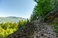
Angel's Rest
Distance: 4.4 miles.
Elevation Gain: 1400 feet.
Angel’s Rest resides high over the Columbia River on the western end of the gorge, offering up some incredible views. Rising almost 1500 feet above the river below, this lava bluff has cliffs that drop away form on three sides, and some of the sunrise and sunset views can be breathtaking. Just don’t expect to see them alone. This trails proximity to Portland and it’s just all-around coolness make it extremely popular.
Begin your hike from the Angels Rest trailhead right off the Historic Columbia River Highway, near Bridal Veil. The main parking area is fairly small, with room for only about 15-20 cars. This may have sufficed for visitors when the highway was constructed over 100 years ago, but you may as well buy a lottery ticket if you manage to find a spot there now. Or you could be one of those crazy morning people, but we aren’t talking about you right now. There is also an upper parking area just to the west on Palmer Mill Road. The actual parking area is small, but people will line the road on both sides. There is still a good chance you won’t be able to find a spot to park, so I would also consider the shuttle from Rooster Rock State Park.
The trail up to Angel’s Rest is a pretty constant, uphill climb. Don’t expect much reprieve along the way, but the steepness isn’t overwhelming either. Just, nice and steady for a little over 2 miles. Pretty quickly, the trail will carve its way through a scree field on the side of the hill, and the going will get extremely rocky. Don’t worry though, the whole trail isn’t like this and you will pass through it quickly.
About half a mile into the hike, you will come to a side trail that will take you to viewpoint off Coopey Falls. Coopey Falls drops 150 feet into a convent owned by the Franciscan Sisters of the Eucharist. The trail continues uphill and just a little bit, you will encounter another junction. If you head left here, you will find yourself on a viewpoint overlooking Coopey Creek. The top of Coopey Creek Falls is just below you, and you really can’t see much of anything there. Upper Coopey Creek Falls can be seen upstream, but it much easier viewed before leaf out. During the late spring through fall, all the vegetation can hide his 23-foot-tall falls from view.
Continue heading up the trail and cross a bridge over Coopey Creek, just above the Upper Falls. About a mile into the hike, you will start entering into the burn scar from the 2017 Eagle Creek Fire. You will also round a ridge at about the same time and get your first views of Angel’s Rest and its cliff lined summit ahead of you.
Once you enter the burned areas, the trail will really start switchbacking as it climbs. Continue pushing upward, getting ever closer to your goal. Finally, right below the summit cliffs, you will find yourself on a long straightaway again, and having to cross through a small boulder field. The rocks are pretty easy to navigate as you make your way through, and they seem very stable. There is a fair amount of poison oak along this stretch, so watch where you put your hands.
You will make one final switchback and then be on the homestretch to Angel’s Rest. As you approach, the ridge top will narrow and you will be picking your way around some andesite pillars. There will be one spot where you will need your hands to climb up past a pillar, but it is pretty easy. And then, BOOM, there you are, standing on top of a million year old lava from Larch Mountain, high over the Columbia. You can gaze west towards Sand Island and the Portland skyline. Larch and Silver Star Mountains loom straight across the river to the north and the summit of Mt Adams is even visible to the east.
Directions
To reach the Angel’s Rest Trailhead, just hop on I-84 and take exit 28 towards Bridal Veil. Follow Bridal Veil Road for a third of a mile to the junction with the Historic Columbia River Highway. If you are coming from the east, you will have to leave 84 on exit 35 towards Ainsworth State Park and follow the historic highway 7 miles west from there. The trailhead is right at the junction of the Historic Highway and the Bridal Veil exit road. If this parking area is full, there is overflow parking just to the west. Turn right onto the Historic Highway and make a left onto Palmer Mill Road. There is a small parking area and roadside parking along this road. Don’t park along the Historic Columbia river Highway itself, or you will probably return to find your car towed.
A second option is to ride the Sasquatch Shuttle. They have a parking area right off the Bridal Veil Exit and down West Mill Road. It will cost you $5 to park in their secure parking area and then $10 per person to rude the shuttle. It will stop at the Angel’s Landing trailhead. Granted, its only about a 1/3 of a mile from the parking area to the trailhead, but it does save you a ton of headache of trying to find somewhere to park.
Things to Know
Passes: No passes are required
Dogs: Dogs are allowed and must be on leash.
Usage: Heavy
Flowers: The area can errupt into an impressive display of wildflowers in April and May with Trillium and Larkspur dominating the trail.
Hazards: Watch out of Poision Oak on the upper reaches of the trail. And you will be on top of a cliff, so don't fall.
Open Season: All year. Trail can get slippery or even snowy in the winter when it is wet.


