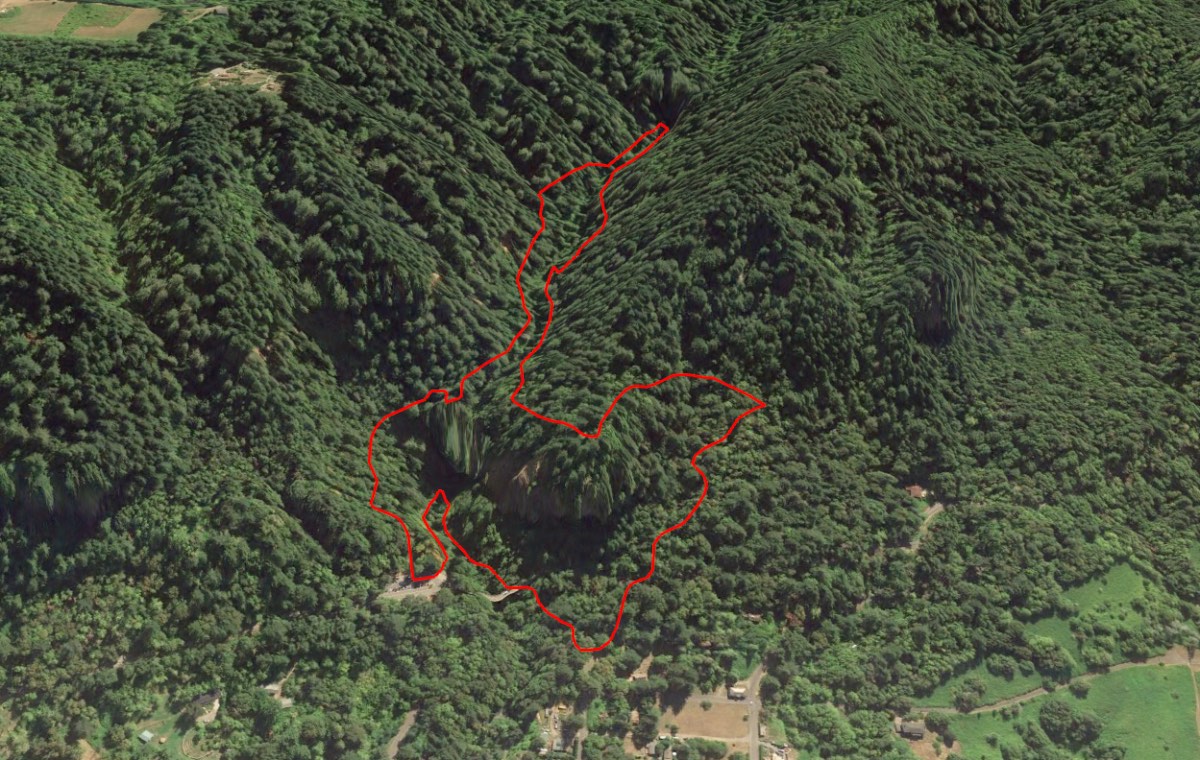
Latourell Falls Loop
Length: 2.0 miles
Elevation Gain: 750 feet
Latourell Falls marks the gateway into the Columbia River Gorge’s gauntlet of waterfalls, being the first major waterfall you come to as you head east from Portland. The lower falls are viewable right from the Historic Columbia River Highway, but take this beautiful trail to get up close and personal to the lower falls and travel another mile into the gorge to the base of Upper Latourell Falls.
You can begin your hike from the Latourell Falls trailhead, right off the highway, or from the Guy W. Talbot State Park picnic area, just below the highway. I like to begin my hike there, and head to the left. This gets the biggest climb of the hike done early and saves Lower Latourell Falls as a nice reward at the end of the hike.
From the picnic area, head up the trail that angels slightly to the right, as it works up past the picnic pavilions. The path will soon diamond crisscross its way up a small hill up towards the highway. Take care in crossing this busy road and then begin your climb. This section climbs over 300 feet in about a ¼ mile as you work your way up to the ridgeline above Lower Latourell Falls.
As you round a sharp bend turning to the right, you will be granted some nice views of the Columbia River from your suddenly much higher vantage point. As you continue to round the corner, you will slowly drop down over the ridgeline as the trail descends towards Latourell Creek. Just before reaching the creek, a side trail will take you to an overlook if you choose. The overlook is perched right over the lower falls, but the views of the falls themselves are pretty obscured. The viewpoint is also fairly precarious, sitting on top of a large cliff with no railings, so be sure to take care if you make the side trip.
The trail heads up the western side Latourell Creek for the next half mile. One highlight along this stretch of trail is the famous cedar “arch”, an old cedar tree that is split at its base with an opening large enough to walk through. Soon, you will find yourself at Upper Latourell Falls. There is a small bridge to lead you over the creek near the base of the falls. From here, you can only see the bottom half of this 134-foot falls, so once you pass it, be sure to turn around and marvel as the upper half slides down a steep basalt face before twisting and free falling into the falls you were just standing next to.
Once you leave the upper falls, the trail continues down the east side of the creek as it works its way to Lower Latourell Falls. You will be awarded your first viewpoint of the falls at a bench as you begin the steep descent of the lower bowl. Here, you can see most of the 225-foot drop, but don’t worry, because even more impressive views are to come.
The trail continues to descend steeply towards the highway and is less than a quarter mile, you will find yourself at the Latourell Falls parking area. Head to your left and reach a beautiful viewing area of the lower falls. The trail continues from here, heading down to the base of the falls and into an amphitheater of lichen covered basalt. Continue over a small bridge and then follow the trail as it heads under the highway and back towards the picnic area.
Directions
From Portland, take I-84 east for about 25 miles and take exit 28 towards Bridal Veil. Continue on Bridal Veil road for about a quarter mile until you reach the Historic Columbia River Highway. Make a right on the highway and travel 2.8 miles to the Latourell Falls trailhead.
From the east, take I-84 west for 26 miles past Hood River. Take exit 35 towards Ainsworth State Park and exit onto the Historic Highway. Follow the highway for 10 miles until you reach the trailhead.
If you want to head to the picnic area, make a right onto Latourell Road just before the main parking area. This road will wind down to the little community of Latourell. At the first intersection, head straight on 2nd St, then follow the road as it turns left on Park St. Make another left as you hit another intersection with Latourell Rd. This road borders the picnic area and parking is along the right.
Things to Know
Passes: No passes are required
Dogs: Allowed and must be on leash.
Usage: Heavy
Open Season: All year. Winter storms may result in ice and make the trip very unpleasent.