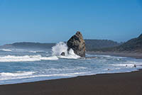
Cape Blanco to Sixes Beach
Distance: 3.0 mile
Elevation Gain: 200 feet.
Cape Blanco, meaning “white cape” in Spanish, was first sighted and named by a Spanish explorer in 1603. The meaning behind the name is somewhat of a mystery, being that the cliffs are more reddish in color, but one theory claims that the fossilized shells found in the cliff face were responsible for the naming. Cape Blanco is the western-most point in Oregon and its cliff rise 200 feet above the pounding sea bellow. It is also probably one of the windiest, where gust as high as 184 mph have been recorded.
Begin the hike from the trailhead located right at the gate for the lighthouse road. The trail heads through the grass as it drops quickly down to the beach. You will fins yourself standing in the sane in less than a quarter of a mile.
Once you reach the beach, exploring is up to you. The beach extends all the way to the moth of Sixes River, about 1.5 miles away. There is also a trail that will take you up the Sixes River towards the Hughes House, if you want to little extra exploring. At the very least, you should head about half a mile down the beach towards a very impressive sea stack. You can watch the waves crash into it and see the spray shore into the air. The walk back up the beach is also enjoyable, with views of Cape Blanco and its lighthouse up ahead, as well as all the jagged rocks surrounding the cape.
Directions
To reach Cape Blanco, head north of Port Orford for 4 miles or south of Bandon for 22 miles on Highway 101. Watch for the signs directing you to the west towards Cape Blanco State Park. Follow the road for 5 miles until you reach the trailhead, just past the campground. There will be a dirt parking area on both sides of the road, along with an informational kiosk on the right, right before you pass through the gate heading up to the lighthouse.
Things to Know
Passes: No passes are required.
Dogs: Dogs are allowd but must be on leash.
Usage: Moderate
Open Season: The state park is open and accessible year round. Don't be surprised to find high winds or dense fog, especially in the more wintery months.


