Chimney Rock
Length: 2.7 miles
Elevation Gain: 620 feet.
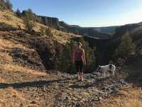
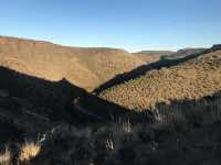
Chimney Rock is a unique rock formation located on the canyon rim above the Crooked River. It resembles a chimney, if you can imagine that. It is located along the Wild and Scenic portion of the Crooked River above Prineville. Within the canyon, 50 million years of geologic history are on display. Different, colorful layers of basalt, ash, and sedimentary deposits from numerous different eruptions occurring over thousands of years are all visible along the hike.
The trail starts at the Chimney Rock trailhead, located just across the highway from the Chimney Rock Campground. The trail begins to climb the canyon right off the bat as it works its way into a side canyon. At about the 0.8-mile mark, you will cross over the top of a dry waterfall and then begin a couple of switchbacks as you head to the canyon rim. The terrain here is fairly steep and a fall off the side of the trail would not improve your day, so be sure to watch your step.
You will reach to top of the Canyon after about a mile and 550 feet of climbing. If you want to catch your breath, there is a nice bench at this point overlooking the canyon and the Cascades in the distance. It’s only another 0.3 miles of fairly flat walking to reach Chimney Rock, and there is another bench waiting for you there right at its base.
Directions
Take Highway 27, or Main Street, south from Prineville for about 17 miles. The trailhead is located on the left side of the road, right across from the Chimney Rock Campground.
Things to Know
Passes: No passes are required.
Dogs: Allowed and must be on leash or under voice command at all times.
Usage: Light
Open Season: Open year round.