Tumulus Loop
Distance: 10.7 miles.
Elevation Gain: 300 feet.
The Oregon Badlands offer a diverse landscape for those who wish to explore the Central Oregon high desert. They also a particularly alluring destination during times of the year when higher elevation trails are blocked by snow. The Badlands were formed about 80,000 years ago when a lava tube flowing beneath the area formed a hole in its roof, allowing lava to boil out in all directions. The area is now home to some of the oldest Western Junipers in Oregon (some more than 1,000 years old), as well as numerous bird and wildlife species, such as golden eagle, sage grouse, prairie falcon, mule deer, elk, and pronghorn.
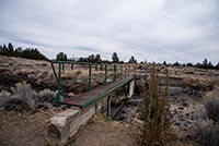
Begin your hike from the Tumulus Trailhead near Alfalfa and head out over the walkway that bridges the canal. The trail will head off to the east for about half a mile through the juniper and rabbit brush until you reach the intersection with the Black Lava Trail. Continue straight on the Tumulus Trail and keep heading down the canal.
After about a ¼ mile more of following the canal, the trail will begin to sweep to the south. The terrain will start to get a little rockier and the vegetation will start to transform into primarily juniper and sagebrush. The further south you go, the cooler the rocks will become, with ridges of layered basalt jutting out of the ground. You will also notice how sandy the soil becomes. This soil is actually volcanic ash remnants from the eruption of Mt Mazama 2,500 year ago, which formed Crater Lake. This is really the most difficult part of the hike. The area will become so sandy, it will almost be like walking on the beach at times, and not the nice wet, packed down part.
You will reach the intersection of with the Basalt Trail 1.25 miles after leaving the canal. If you’ve had enough, you can cut your hike short by about 6.7 miles by taking this cutoff over to the Black Lava Trail. If you want to see all the badlands have to offer, keep on heading down the Tumulus Trail.
About half a mile after the junction with the Basalt Trail, you will enter the actual Badlands portion of the Oregon Badlands. Here, lava ridges and domes have boiled up everywhere. Junipers cling to the rock and are all gnarled and cool looking and the ground transitions to almost pure sand. The trail is like a maze as it winds its way through and around all the obstacles.
Three miles from the Basalt Trail, you will reach the Mazama Ash Trail. Take this trail as it branches off to your right. You will leave the more defined old two-track road of the Tumulus Trail here and dive into a single-track trail, kind of. It’s hard to define a trail constructed in sand where there is very sparse ground vegetation, but it is not too hard to follow. Rock cairns have also been constructed along the trail to help guide you on your way.
The Mazama Ash Trail guides you through some more interesting rock formations as winds along the southern portion of the loop. In 2.2 long, slogging miles (you may need to dump your shoes out here), you will reach the Black Lava Trail. This trail again transitions back into an old two-track road as you head back towards the trailhead. There will be some nice views of the Cascades along this stretch as well as some signs of previous civilization, such as old fence lines, an old dump site, and even an old corral built into a natural rock amphitheater. Pass by the Basalt cut-off trail that you may have wished you took about halfway back, and keep trekking until you reach the Tumulus Trail again. Bank to the left and head back over the canal in half a mile. I’m sure your car will be a sight for sore eyes.
Directions
From Bend, head east on Highway 20 from the Junction with 27th St for 2.2 miles and then take the Powell Butte Highway to the North, towards Prineville. Take the Powell Butte Highway for 0.9 miles until you reach the traffic circle. Take the first exit out of the Traffic Circle and follow Alfalfa Market Road for 8.4 miles. Once you start reaching the farmlands, watch out for Dodds Road, and make a right onto it. Head down Dodds Road for 1.6 miles and then make a left onto a dirt road.
The dirt road is in pretty good condition, with some rocks but nothing most cars can’t make it past. In a little less than half a mile, the road will branch. Head south, to the right, and you will find yourself at a nice turnaround spot right near the canal. This is where you will begin your quest. Good luck.
Things to Know
Passes: No passes are required.
Dogs: Allowed and must be on leash or under voice command at all times.
Usage: Light
Open Season: All year but summer can get very hot and there s very little shade and no water.


