High Lake
Distance: 2.5 miles
Elevation Gain: 515 feet.
Sitting nestled against the northern ridge of Rabbit Ears high in the Strawberry Wilderness sits High Lake, a beautiful 5 acres circle lake surrounded by rocky cliffs. This lake can be accessed via a backpacking trip that begins at the more popular Strawberry Lake Trailhead and circles through the wilderness or, as seen here, a relatively easy day hike from the southern end of the Strawberry Wilderness.
The trail begins at the High Lake Rim trailhead at the end of Forest Road 1640. This hike begins at almost 8000 feet, so be prepared for rapidly varying weather conditions during any season. The trail quickly dives over the edge of the ridge and begins heading down to High Lake, which can be seen nestled up against the mountain ridges in the distance. The High Roberts fire burned much of this area in 2002, leaving a mostly open canopy and snags aplenty. But the additional light also allows wildflowers to flourish.
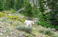
The trail is relatively short to High Lake and you will be there in no time. It does drop over 500 feet though, so be prepared for that on your hike out. As you approach the lake, you will cross over a couple of creeks and wet areas. Once you reach the lake, follow the shores to the right to get the best views of Rabbit Ears and Indian Spring Butte rising behind the lake. And keep you r eyes open, you may even spot a mountain goat or two.
Directions
To reach the High Lake Rim Trailhead, take Highway 395 between John Day and Burns. If you are coming from the north, turn left onto Forest Road 15 10 miles south of John Day and follow that for 13.7 miles until you reach the junction with Forest Road 16. Make a left onto 16 and continue for another 6 miles and make a left onto road 1640. If you are coming from the south, turn right onto Forest Road 16 in the town of Seneca, 45 miles north of Burns. Follow 16 for 14 miles until you reach the 1640 road.
Once on the Forest Road 1640, things can get a little confusing. You will want to stay on the 1640 road all the way to the trailhead, but the roads aren’t really signed out there. Its about 11 miles up the gravel and dirt road to reach the trailhead, but the road is in relatively good condition the whole way up. Most vehicles with Subaru level toughness or better should make it fine. There are several roads the shoot off from the 1640, but generally they don’t appear as developed. There is one fairly significant intersection about halfway up, and you will want to bear left here. For the most part, you will be driving uphill the whole way so if you find yourself driving back downhill for a decent distance, or the road turns to crap, you are going the wrong way. Once you reach the top, there will be two trailheads. You will pass by the Road’s End trailhead first but keep going about a quarter mile to reach your destination.
Things to Know
Passes:A free, self-issue wilderness permit is required upon entering the wilderness.
Dogs: Allowed and must be on leash or under voice control and all times.
Usage: Light.
Open Season: The road to the trailhead is never offically closed, but expect to encounter snow somewhere along it sometimes into June or July
Bugs: Mosquitoes can be plentiful here during June and July.
Flowers: Flowers will be blooming along much of the trail in July and early August.