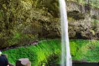
Silver Falls - South Fork Falls
Length: 2.5 miles
Elevation Gain: 400 feet.
Silver Falls State Park is the largest State Park in Oregon and contains one of the highest concentrations of large waterfalls anywhere in the US. If you don’t have time to hike the entire Trail of Ten Falls, this quick loop down the South Fork Silver Creek allows you to visit two of the more impressive falls, including the iconic South Falls. The downfall of this stunning display is visitors. Don’t expect much solitude along the trail and you may even encounter a traffic jam or two as dozens or even hundreds of people line up in the narrow grottos behind South Falls and Lower South Falls. Dogs are also not allowed on the Canyon Trail, the part of the hike which leads you up close and personal to the two falls.
Begin your hike at the South Falls Day-Use Area where there is a huge parking area and is also the location of South Falls Lodge. It is a small, beautiful stone building built by the CCC in the 1930s that offers some food and a nice fire during the chillier months. From the parking area, head past the lodge and follow the signs to South Falls. The trail quickly begins heading down the steep canyon, but first you will be rewarded with a viewpoint over the falls. The trail can be wet most of the year on its way down the canyon, so watch your step. As you get to the first switch back, there will a short side trail to Frenchie Falls heading to the right. This is a smaller falls at 48 feet without much flow (It completely dries up in the summer), but if you’re wanting to hit every fall you can, head on up and take a gander.
After the switchback, you will head back to South Falls and then be rewarded with one of the coolest experiences in Silver Falls State Park, the ability to walk behind the falls. These caverns behind the falls were created millions of years ago when lava flowed over the entire landscape, burying softer, older rock. As the eons past, the stream slowly carved through the harder, upper layers of basalt, and as they did, the softer, lower layers easily eroded away, creating these large bowls behind some of the larger falls.
After passing behind South Falls, don’t cross the bridge over the South Fork of Silver Creek but continue down the Canyon Trail instead. You will reach Lower South Falls in just half of a mile. As you approach the falls, the trail heads down a steep section of stairs and then travels behind this falls as well. The cavern is much smaller here though, and wetter. Expect puddles in your path as you squeeze by people. Once you’re through, continue down the creek for less than half a mile until you reach the North Fork of Silver Creek. Here, head to the right on the Maple Ridge Trail and begin your climb up out of the canyon.
The climb up the Maple Ridge Trail is fairly steep, gaining about 400 feet in less than half a mile. But once you are up, your good. The trail then winds its way through the trees along the edge of the canyon for the next mile as you head back towards the lodge. Because of how dense the forest is, there isn’t much of a view down the canyon. However, you will get to see another view or two of South Falls as you reach the end of your hike.
Directions
If you are coming from Salem, take Highway 22 east until you reach Exit 7. There will be a sign directing you to Silver Falls State Park. If you are coming from the east, take Exit 13 towards Sublimity and head north. Both routes will meet at the intersection of 214 and the Cascades Highway. From there, head east on 214 and follow the signs. While it is only 10 miles from this point, it will be slow and windy and you will undoubtedly get stuck behind a land yacht, so be patient. Once you’re in the park, head in to the South Falls Day Use Area on your left and begin your quest for a parking spot.
Things to Know
Passes: A $5 day use permit is required.
Dogs: Dogs are not allowed on the Canyon Trail.
Usage: Heavy
Open Season: Open year round. Flows over the watefalls are much more dramatic in the winter and early spring, so much so that you can count on getting wet when walking behind them. The flows on some of the falls will almost dry up by late summer.


