Willow Springs Preserve Loop
Distance: 1.9 miles
Elevation Gain: 200 feet.
Willow Springs Preserve is a 129 acre parcel of land located along Whychus Creek near Sisters. The preserve was purchased by the Deschutes Land Trust to help protect the creek and it’s meadows is it flows through this rocky canyon. The area is some to aspen and cottonwood stands and hosts habitat for salmon, steelhead, mule deer, elk, and raptors. It is also private and access is only allowed if you join a tour. EXCEPT for this loop.
The Willow Springs Preserve Loop is located almost entirely within the Deschutes National Forest. The far end of it does cross into the preserve however, allowing some nice views down towards the Whychus Creek meadows from the top of the rimrock cliffs to the west. So if you’re looking for a quick outing in the woods near Sisters, this hike makes a great option.
The trail begins in a small parking area at the end of Deer Ridge Road in Sisters. The trail heads out of two directions because, as you may know from the title, it’s a loop. I feel like the views are better if you head left and take the northern trail first though. So heed my words and go that way.
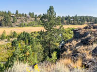
The trail meanders up and down draws and passes in and out of wooded areas and scabland flats. There are several user trails that offshoot from this main on, but if you just keep staying left until you get to the cliffs, you will be good. At 0.6 miles, you will cross into the Willow Springs Preserve. There will be a sign marking the boundary and letting you know the rules of the area. (Don’t bring your dog on this one). Soon after passing the sign, you will reach the cliffs overlooking the meadows.
The trail hugs the cliff’s edge for about half a mile as you travel upstream. During the fall, the leaves of the aspens and cottonwoods will be a vibrant yellow and orange. You can also view some of the restorative actions the Deschutes Land Trust is taking along the creek.
Eventually, the trail will turn away from the canyon and make it’s way back towards the Deschutes National Forest. But the good times aren’t over yet. Soon you will enter a large, open scabland and the Three Sisters will dominate the skyline ahead of you. Enjoy it while you can because you will soon dive back into the Ponderosa Pine’s and will be back at your car in no time.
Directions
To reach the Willow Springs Preserve Loop trailhead, take Locust Street north from the east side of town. Follow Locust for half a mile until it turns into Camp Polk Road. Continue along Camp Polk Road for another 1.8 miles. Right after crossing over the meadows of Indian Ford Creek, make a right onto Deer Ridge Road. This road travels through a neighborhood, so drive respectfully. After 1.1 miles, the road will end in a dirt parking area that is the trailhead.
Things to Know
Passes: None.
Dogs: Not permitted within the Preserve
Usage: Light.
Open Season: The area is accessible year round, but don't be surprised if the trail is snow covered in the winter.
Restrictions: In the preserve, foot travel only is permitted. Removal of any plants or rocks is also prohibitied. And there is no camping or camp fires.