Whychus Canyon Preserve - Rim and Creek Trail Loop
Distance: 4.8 miles.
Elevation Gain: 400 feet.
The Whychus Canyon Preserve is a conservation area purchased by the Deschutes Land Trust in 2010. This area protects 4 miles of Whychus Creek and over 1400 acres of transition habitat as Ponderosa Pine forests give way to drier Juniper and Bitterbrush savannahs. There are a number of different trails within the Preserve that are open to the public, and the Rim and Creek Trails Loop is probably the most dramatic.
Begin your hike from the small trailhead at the end of Goodrich Lane. There will be some informational kiosks and signs present to let you know you are in the right place. Two trails will leave from the trailhead. Take the single track trail towards the Rim Trail, which will be the leftmost of the two trails and not the one that looks like an old road.
Follow the Rim Trail Connector for 0.15 miles before reaching a gate marking the entrance from BLM into the Whychus Canyon Preserve. Once through the gate, the Rim Trail will T and head in both directions. We headed right, but feel free to choose any direction you prefer.
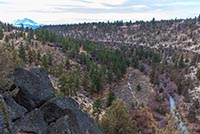
As you follow the Rim Trail, the path will slowly lead you into the canyon. You will be below the actual top of the canyon, but just far enough in that you can see down into it. Be sure to look behind you from time to time for some nice views of North and Middle Sister. A little over half a mile into the hike, you will reach another junction. If you are looking to just make a short, 2-mile loop out of your day, you can make a left here and connect to the southern end of the Rim Trail. If you’ve got more juice in you, head right and carry on.
You will continue along the canyon rim among some beautiful bunch grasses, bitter and sage brush, and juniper, and Ponderosa Pines for the next 0.6 miles before reaching a nice overlook. Here, you will find a bench to take a rest and enjoy some dramatic views looking down the canyon. Shortly after the overlook, another connector trail can take you down to the Creek Trail, if you desire. Just be forewarned that the trail is very steep. It would cut about 1.5 miles off the loop total, but there is still some cool stuff to see if you proceed onward.
You will reach the junction with the Meadow Trail about a quarter mile following the overlook. Make a left here to stay on the Rim Trail and to continue your loop. The trail transitions for a single track to an old road here and makes for some easy walking for a little while. After only being on the wider trail for a tenth of a mile, watch for a small side trail to your left directing you to a viewpoint. This short spur is only about 250 feet long but will take onto a pretty rock outcrop sitting right on the canyon rim. The views up the canyon with the mountains in the background are beautiful.
Once back on the mail trail, the Rim will continue down canyon for a little less than half a mile before making a sharp left and transitioning the Creek Trail. Soon, you will find yourself walking along the canyon bottom on the banks of Whychus Creek. You will weave through willow stands, meander through lush, grassy areas, and enjoy the cool shade offered by the Ponderosa Pines.
The Creek Trail follows Whychus Creek for 1.5 miles before encountering the only real difficult part of the hike. Here, the trail seems to head straight up the canyon, switchbacking back and forth, and gaining over 100 feet in elevation in less than a tenth of a mile. Once up this section, you will find yourself back on the Rim Trail and at another junction. Heading to the left will take you to the first cutoff mentioned above. So head right to complete the loop.
Once up the switchbacks, the trail continues to slowly climb as you travers the canyon walls. Some views of Black Crater and Mt Washington will come into view down canyon as you continue to climb. About ¾ of a mile from the junction, the trail will switchback hard to the left as you begin to head back towards the trailhead and reach the top of the canyon. March along the rim of Whychus Canyon for another 1/3 of a mile before reaching the gate and completing the loop. Head back through the gate and you will soon be back at your car.
Directions
To reach the Whychus Canyon Preserve, take Highway 126 4.5 miles east of Sisters or about 12 miles west of Redmond and head north onto Goodrich Road. If you are coming from Bend, take Highway 20 towards Sisters and make a right onto Fryrear Road, 7 miles past Tumalo. Follow Fryrear Road for 5.6 miles before taking a left onto Highway 126. Goodrich Road will 1 mile ahead and on your right.
Once on Goodrich Road, just head straight north towards the Preserve. After a little more than a mile, Goodrich Road will transition to a hardpacked gravel road and narrow up. It will almost look like a driveway with fenced lined yards on both sides of it. But continue on and 3 miles from the highway, you will reach the trailhead.
Things to Know
Passes: No passes are required.
Dogs: Allowed and must be on leash at all times.
Usage: Moderate
Open Season: The trails are open year round, but can get muddy, icy, or snowy in the winter
Wild Flowers: Wildflowers can be found at differnt places at different times throughout the preserve, but usually range between April and July.
Hazards: Rattlesnakes are present between late spring and early fall and ticks may also be lurking during the spring and early summer along the creek.