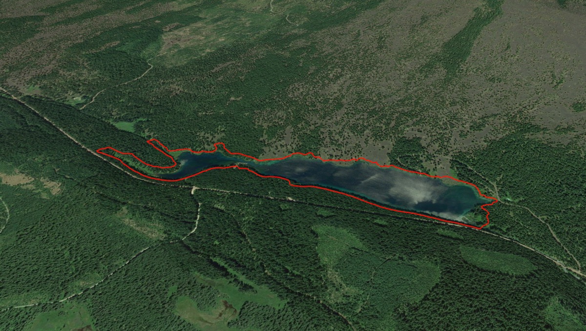
Clear Lake Loop
Length: 4.6 miles
Elevation Gain: 200 feet.
The McKenzie River is a magical waterway, draining the western slope of much of the Central Oregon Cascades. The volcanic legacy of the area has also left its mark, with lava flows burying whole sections of the river causing the McKenzie to flow underground for miles, and damning up the valley, creating Clear Lake.
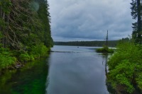
Begin your hike from the Clear Lake Resort, just off of Highway 126. The resort can get pretty busy in the summer, so finding a place to park can be challenging at times. From the resort, follow the roads north, past the lodge and cabins. You will see where the trail starts again, continuing along the western shore. The water of the lake begins to look more aqua here and is very pretty. There is also a small forest of trees just beneath the surface of the lake, preserved by the freezing cold water for the last 3,000 years. Unfortuatenly, you can’t see them unless you rent a boat and paddle out on the water. Just knowing they are there though is kind of cool.
As you round the northern tip of the lake, you will cross over two small streams, Ikenick Creek and Fish Lake Creek. Both these streams dry up seasonally, although it appears that Fish Lake Creek can really get flowing, if you time your visit with a flood or something. The bridge over Fish Lake Creek is also pretty narrow and highish, if you are into those kinds of things. (There are rails. (Highish is like 20 feet. (Quit freaking out. It’s just a bridge))). Also, right before the Fish Lake Creek Bridge, you will join the McKenzie River Trail. Follow the trail that crosses the bridge, not the one that continues upstream.
Shortly after Fish Lake Creek, you will start to notice a small cove of Clear Lake that is getting crazy blue. The trail will head around the cove and you will find yourself at Great Springs. This area is like a little Blue Pool, with a beaituful, deep blue pool of water just appearing out of the ground and flowing into Clear Lake. This is considered to be the source of the McKenzie River. It’s cold too, so no cannon balls.
The trail that continues down the east side of Clear Lake offers much more views than the other side. You will also find yourself picking your way through lava flows. There are tons of ups and downs along this section of trail, some of them quite steep. The rock can start to wear on your feel after a while. About a half mile before reaching Cold Water Cove Campground, the trail will transition to asphalt, giving your tootsies a much-needed break. It does continue to weave its way through the waves of lava though.
Quickly after the campground, the trail will transition back to dirt and round the southern shore of the lake. You will pass a trail that could take you down to Sahalie Falls, if you want to log a few more miles. Otherwise, follow the Clear Lake trail to the right and continue along the lake.
Once you are back on the Clear Lake trail, you will quickly cross a bridge over the McKenzie River, right as is flows out of Clear Lake. This is the head of the mighty river, its birthplace. Kinda cool. So cross the bridge already and continue along the west shore of the lake. The views aren’t that great here as you are often a ways above the shoreline, but there are some pretty areas of flowers in the woods. It's just a mile of easy walking until you find yourself back at the resort.
Directions
The Clear Lake Resort is located right off of Highway 126. The turnoff is located on the east side of the highway, approximately 4 miles south of the Highway 20/126 junction or 16 miles north of the Highway 126/242 junction, if you're coming from the Eugene area.
Things to Know
Passes: Northwest Forest Pass is required at the trailhead.
Dogs: Allowed and must be on leash or under voice command at all times.
Usage: Heavy
Open Season: This area is accessible year round and could be snowshoed during the dead of winter.
Wildflowers: There are some flowers to enjoy, primarily along the west shore of Clear Lake, where some bear grass blooms and rhodendrons will brigthen your day. Late May through early June seems to be the best time to enjoy their display. There is also a lot of Vine Maple along the trail, making fall and wonderful time to visit if you like the changing leaves.