McKenzie River - Kossah and Sahalie Falls to Clear Lake Loop
Length: 8.3 miles
Elevation Gain: 820 feet.
The McKenzie River is a magical waterway, draining the western slope of much of the Central Oregon Cascades. The volcanic legacy of the area has also left its mark, with lava flows burying whole sections of the river causing the McKenzie to flow underground for miles, and damning up the valley, creating Clear Lake. The water of this amazing river can be an unreal blue in places, and the deep, green forest of old growth timber can help cool you on even the hottest day.
There are multiple different areas you can begin your hike from, with trailheads located at two different spots on Clear Lake, at Sahalie Falls, Koosah Falls, and at Carmen Reservoir. Probably the best place to begin you hike would be at Carmen Reservoir, being that it is located at the lowest elevation of the hike and receives much less traffic than the other trailheads. Unfortunately, this area is closed until at least through 2021, so I liked to pick the next best spot, Koosah Falls.
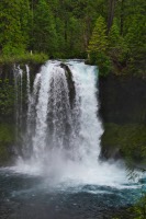
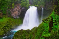
Right from the trailhead, you will find yourself at an overview of this dramatic falls. While only 64 feet high, the shear volume of water plunging over this drop makes Koosah Falls truly dramatic. Once you hit the trail and find the overlook, start heading downstream. There will be a couple other overlooks along the way, granting you different perspectives of the falls.
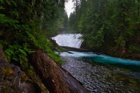
About a third of a mile from the trailhead, you will reach Carmen Reservoir. Water from the reservoir is piped beneath the ridge to the west and dumped into the Smith Reservoir, where it is again piped downstream to the Trail Bridge Reservoir for power generation. Carmen Reservoir also marks the lower end of the upper most section of the McKenzie River. The river enters a wide valley created by a lava flow just below the reservoir, and proceeds to dive underground through the porous rock. It doesn’t emerge again under it pops out at Blue Pool, nearly 4 miles downstream.
This section of trail will grant you some amazing views of both Koosah Falls and Sahalie Falls and you won’t have to fight with the crowds at the overlooks that are right off the highway. There are also some other, smaller falls and rapids between the two offering you more than enough to gawk at along the hike. You will see Koosah Falls quickly, only a quarter mile after joining the McKenzie River Trail, and 73 foot tall Sahalie Falls will come into view a half mile later. This section of trail contains the majority of the climbing along the hike, gaining 500 feet in about a mile. This is also a popular mountain bike trail, so keep your eyes peeled for bikers flying down the trail.
After Sahalie Falls, continue up the river for another 0.4 miles until you cross a bridge back over the McKenzie. Take the trail to the left following the bridge and begin heading towards Clear Lake. You will reach the highway in less than a quarter mile. Cross it near the entrance to Cold Water Cove Campground and continue on the trail for about half a mile until you intersect the Clear Lake Trail.
Once at the Clear Lake Trail, head to the left and begin heading towards the resort. You will quickly cross a bridge back over the McKenzie River, right as is flows out of Clear Lake. This is the head of the mighty river, its birthplace. Kinda cool. So cross the bridge already and continue along the west shore of the lake. The views aren’t that great here as you are often a ways above the shoreline, but they will get better. Patience already.
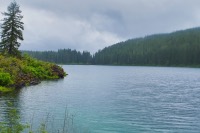
Once you reach the resort, follow the roads past the lodge and cabins. You will see where the trail starts again, continuing along the western shore. The water of the lake begins to look more aqua here and is very pretty. There is also a small forest of trees just beneath the surface of the lake, preserved by the freezing cold water for the last 3,000 years. Unfortuatenly, you can’t see them unless you rent a boat and paddle out on the water. Just knowing they are there though is kind of cool.
As you round the northern tip of the lake, you will cross over two small streams, Ikenick Creek and Fish Lake Creek. Both these streams dry up seasonally, although it appears that Fish Lake Creek can really get flowing, if you time your visit with a flood or something. The bridge over Fish Lake Creek is also pretty narrow and highish, if you are into those kinds of things. (There are rails. (Highish is like 20 feet. (Quit freaking out. It’s just a bridge))). Also, right before the Fish Lake Creek Bridge, you will rejoin the McKenzie River Trail. Follow the trail that crosses the bridge, not the one that continues upstream.
Shortly after Fish Lake Creek, you will start to notice a small cove of Clear Lake that is getting crazy blue. The trail will head around the cove and you will find yourself at Great Springs. This area is like a little Blue Pool, with a beaituful, deep blue pool of water just appearing out of the ground and flowing into Clear Lake. This is considered to be the source of the McKenzie River. It’s cold too, so no cannon balls.
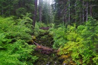
The trail that continues down the east side of Clear Lake offers much more views than the other side. You will also find yourself picking your way through lava flows. There are tons of ups and downs along this section of trail, some of them quite steep. The rock can start to wear on your feel after a while. About a half mile before reaching Cold Water Cove Campground, the trail will transition to asphalt, giving your tootsies a much-needed break. It does continue to weave its way through the waves of lava though.
Quickly after the campground, the trail will transition back to dirt and round the southern shore of the lake. You will complete your loop of the lake about half a mile from the boat ramp at the campground. Stay on the McKenzie River trail and head back downstream towards the falls. Once you reach the bridge this time, don’t cross it and find the trail to Sahalie Falls on the far side of a large, gravel area.
Sahalie Falls is only a half mile below the bridge and you will first come to it by reaching a viewpoint overlooking the top of the falls. Unfortunately, these are the viewpoints located along the highway, so you will likely notice a metric ton of people pressed up against the rails, trying to see. Like Koosah Falls, there are a couple other viewpoints as you head down the trail.
The trail between Sahalie and Koosah is very beautiful, hugging the river along some other, smaller falls for much of the time. It is also fairly steep, requiring you to navigate stairs on the way down, and can also be very muddy. Be sure to stop and check out the river from time to time though, it is magnificent. From Salahie Falls, it is only about half a mile back to the trailhead at Koosah Falls.
Directions
The Koosah Falls trailhead is located just off of Highway 126 at the entrace to the Ice Cap Creek Campground. The turnoff is located on the west side of the highway, approximately 6 miles south of the Highway 20/126 junction or 14 miles north of the Highway 126/242 junction, if you're coming from the Eugene area. Sahalie Falls Trailhead is located just about a half mile north of this and the Clear Lake Resort is a further 1.5 miles north.
Things to Know
Passes: Northwest Forest Pass is required if you park at Clear Lake, but not if you begin your hike from one of the two waterfalls or Carmen Reservoir.
Dogs: Allowed and must be on leash or under voice command at all times.
Usage: Heavy
Open Season: This area is accessible year round and could be snowshoed during the dead of winter. The trail along the McKenzie can get very muddy in the shoulder season.
Wildflowers: There are some flowers to enjoy, primarily along the west shore of Clear Lake, where some bear grass blooms and rhodendrons will brigthen your day. Late May through early June seems to be the best time to enjoy their display. There is also a lot of Vine Maple along the trail, making fall and wonderful time to visit if you like the changing leaves.